Watch our series of short videos on the importance of the
Sacramento-San Joaquin Delta, how it works as a water hub for
California and the challenges it is facing.
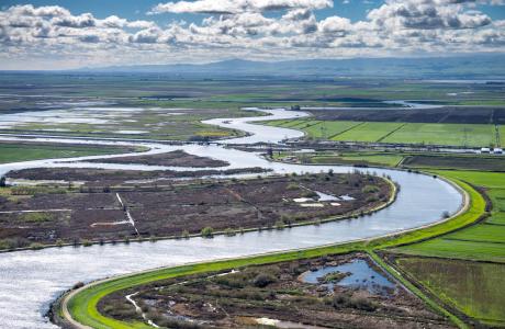
When a person opens a spigot to draw a glass of water, he or she
may be tapping a source close to home or hundreds of miles away.
Water gets to taps via a complex web of aqueducts, canals and
groundwater.
Learn more about our team in the office and on the Board of
Directors and how you can support our nonprofit mission by
donating in someone’s honor or memory, or becoming a regular
contributor or supporting specific projects.
Unlike California’s majestic rivers and massive dams and
conveyance systems, groundwater is out of sight and underground,
though no less plentiful. The state’s enormous cache of
underground water is a great natural resource and has contributed
to the state becoming the nation’s top agricultural producer and
leader in high-tech industries.
A new era of groundwater management began in 2014 in California
with the Sustainable Groundwater Management Act. The landmark law
turned 10 in 2024, with many challenges still ahead.
In December 2012, dam operators at Northern California’s Lake Mendocino watched as a series of intense winter storms bore down on them. The dam there is run by the U.S. Army Corps of Engineers’ San Francisco District, whose primary responsibility in the Russian River watershed is flood control. To make room in the reservoir for the expected deluge, the Army Corps released some 25,000 acre-feet of water downstream — enough to supply nearly 90,000 families for a year.
Registration is now open for
the Water Education Foundation’s 41ˢᵗ annual
Water Summitfeaturing leading
policymakers and experts in conversation about the latest
information and insights on water in California and the West.
New information is emerging about what’s being negotiated
between the seven states who rely on the Colorado River: an
“amicable divorce” between the Upper and Lower Basins. At a
meeting of a council made up of farmers, ranchers and other
Colorado River water users here, the head of the Colorado River
Authority of Utah disclosed some of what was being negotiated.
… It’s basically a separation between the Upper
Basin states of Wyoming, Utah, Colorado and New Mexico and the
Lower Basin states of Arizona, Nevada and California.
… Lake Powell would basically be maintained at a certain
level to keep both basins happy, (Colorado River Authority of
Utah Executive Director Amy) Haas clarified to FOX 13 News. She
would not disclose specific percentages as each side and the
federal government is doing their own modeling. The Lower Basin
states also have pledged to reduce their share by 1.5 million
acre feet, she said.
Two Central Valley Democrats are pitching a new water bill
designed to protect water access for the region’s
farmers. Rep. Adam Gray (D–Merced) introduced the Valley
Water Protection Act last week and was joined by Rep. Jim Costa
(D–Fresno). The Valley Water Protection Act would amend
the Endangered Species Act (ESA) to protect
farmers from enforcement actions that could pose national
security threats or regional economic harm. … The bill
has widespread support from water users across the Central
Valley, including the Turlock Irrigation District, the Merced
Irrigation District, the Modesto Irrigation District, the San
Luis and Delta-Mendota Water Authority and the Friant Water
Authority. … Along with Gray’s bill, Westerman
introduced the Endangered Species Act Amendments Act of 2025,
which would streamline the ESA permitting process and establish
clear definitions within the act.
In recent years, scientists and water managers have started
using the term “snow drought” to describe meager snowpacks in
the American West. … Because a lack of snow has
such profound implications for the West’s water supply,
wildfire risk, recreational activities and ecosystem health,
the federal government now regularly tracks the severity of
snow drought across the region. The reports rely on data from
hundreds of SNOTEL stations—a network of automated sensors that
use “snow pillows” to weigh the snowpack and calculate its
water content—but federal budget cuts may hamper that system
going forward. To learn more about snow droughts, I
recently spoke with one of the authors of those reports: Dan
McEvoy, regional climatologist at the Western Regional Climate
Center and the Desert Research Institute.
Housing developers left stranded and stalled by a lack of an
assured water supply are getting a lifeline under a deal cut
between Republicans and Democratic Gov. Katie Hobbs. The
proposal, known as “Ag-to-Urban,” allows homebuilders
to buy water rights from farmers who retire their agricultural
land if they promise to use only a certain percentage of the
water to supply new developments. … The deal
immediately affects only Maricopa and Pinal counties, but the
Pima County Active Management Area may also fall under its
guidance if a moratorium on new water certificates is put in
place by state water regulators, (Sen. T.J.) Shope said. If all
three areas were included, more than 400,000 acres of farmland
could be eligible for conversion. … While big developers
are celebrating a win, elected officials in rural Arizona are
criticizing Hobbs for backing the proposal without tying it to
new protections for groundwater in their areas.
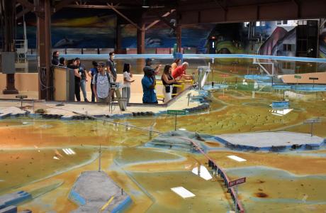
Operated by the U.S. Army Corps of Engineers, the
Bay Model is a giant hydraulic replica of San Francisco
Bay and the Sacramento-San Joaquin
Delta. It is housed in a converted World II-era
warehouse in Sausalito near San Francisco.
Hundreds of gallons of water are pumped through the
three-dimensional, 1.5-acre model to simulate a tidal ebb
and flow lasting 14 minutes.
As part of the historic Colorado
River Delta, the Salton Sea regularly filled and dried for
thousands of years due to its elevation of 237 feet below
sea level.
The most recent version of the Salton Sea was formed in 1905 when
the Colorado River broke
through a series of dikes and flooded the seabed for two years,
creating California’s largest inland body of water. The
Salton Sea, which is saltier than the Pacific Ocean, includes 130
miles of shoreline and is larger than Lake Tahoe.
Drought—an extended period of
limited or no precipitation—is a fact of life in California and
the West, with water resources following boom-and-bust patterns.
During California’s 2012–2016 drought, much of the state
experienced severe drought conditions: significantly less
precipitation and snowpack, reduced streamflow and higher
temperatures. Those same conditions reappeared early in 2021
prompting Gov. Gavin Newsom in May to declare drought emergencies
in watersheds across 41 counties in California.


")