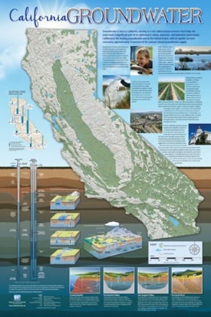
Header link June 22, 2020

LinkedIn

  • Read more
Header link September 15, 2014

Cart

  • Read more
Header link November 3, 2015

Donate Now

  • Read more
Header link May 15, 2014

Twitter

  • Read more
Header link May 15, 2014

Facebook

  • Read more
Instagram
Header link May 15, 2014

Instagram

  • Read more
Header link May 15, 2014

Contact Us

  • Read more
More options
Water Education Foundation
Home

Water Education Foundation

Everything about California water that matters
  • Water Academy
    • Agriculture
      • Agricultural Conservation
      • Agricultural Drainage
    • Background Information
      • Legislation — California and Federal
      • Regulations — California and Federal
      • Water History
      • Water Rights
    • Bay-Delta
      • Bay Delta
      • Bay Delta Conservation Plan
      • Delta Issues
      • Delta Smelt
      • Sacramento San Joaquin Delta
      • San Francisco Bay
      • Suisun Marsh
    • Dams, Reservoirs and Water Projects
      • California Aqueduct
      • Central Valley Project
      • Folsom Dam
      • Friant Dam
      • Hetch Hetchy
      • Hoover Dam
      • Infrastructure
      • Lake Mead
      • Lake Powell
      • Oroville Dam
      • San Luis Dam
      • Shasta Dam
      • State Water Project
    • Environmental Issues
      • Anadromous Fish Restoration
      • Ecosystem
      • Endangered Species Act
      • Invasive species
      • Lake Tahoe
      • Mono Lake
      • Public Trust Doctrine
      • Salmon
      • San Joaquin River Restoration
      • Watershed
      • Wetlands
    • Leaders and Experts
    • Regions
      • Central Coast
      • Central Valley
      • Mexico
      • Nevada
      • North Coast
      • Pyramid Lake
      • Sacramento Valley
      • Salton Sea
      • San Joaquin Valley
      • Sierra Nevada
      • Southern California
      • Tulare Lake Basin
    • Rivers
      • Carson River
      • Colorado River
      • Klamath River
      • New River
      • North Coast Rivers
      • Russian River
      • Sacramento River
      • Truckee River
      • San Joaquin River
    • Water Issues
      • Climate Change
      • Coronavirus
      • Drought
      • Earthquakes
      • Energy and Water
      • Floods
      • Fracking
      • Growth
      • Hydropower
      • Levees
      • Tribal Water Issues
      • Water Conservation
    • Water Quality
      • Drinking Water
      • Nitrate contamination
      • Pollution
      • Stormwater
      • Wastewater
      • Water Quality
    • Water Supply and Management
      • Acre Foot
      • Aquifers
      • California Water Plan
      • Conjunctive Use
      • Desalination
      • Grey water
      • Groundwater
      • Integrated Regional Water Management
      • Recreation
      • Surface Water
      • Water Marketing and Banking
      • Water Rates
      • Water Recycling
      • Water Supply
      • Water Transfers
  • Tours & Events
    • Water Tours
      • 2024 Tour Sponsors
    • Events
    • Event Calendar
    • Past Tours & Events
      • Anne J. Schneider Fund Lecture Series
  • Specialized Programs
    • Water Leaders
      • Cohort Rosters
      • Yearly Class Reports
      • Your Alumni Network
      • Alumni Profiles
    • Project WET
      • Workshops
      • Special Workshops & Events
      • Supplementary Materials
      • California Content Standard Correlations
      • Facilitator's Trainings
      • Foundation School Programs
        • Elementary Programs
        • Secondary Programs
      • Water Kids
      • California Project WET Gazette
      • Gazette Archives
    • Colorado River Project
    • GRA Scholastic Fund Program
  • Maps & Guides
    • Maps & Posters
    • Layperson's Guides
    • Map & Guide Bundles
    • Books
    • Colorado River Materials
    • California Runoff Rundown
    • Other Publications
    • Water Awareness Materials
    • Downloadable Publications
    • Videos and DVDs
      • Video Clips
    • School Age Publications
    • Stickers
    • Free Programs and Publications
  • Newsroom
    • Western Water News
    • Aquafornia
      • About Aquafornia
    • Information Desk
    • Western Water Magazine Archive
      • Full Print Edition
      • Print Edition Excerpts
    • River Report Archive
  • Aquapedia
    • Alphabetical List of Subjects
      • A
      • B
      • C
      • D
      • E
      • F
      • G
      • H
      • I
      • J
      • K
      • L
      • M
      • N
      • O
      • P
      • Q
      • R
      • S
      • T
      • U
      • V
      • W
      • X
      • Y
      • Z
    • Historical Water People
    • Where Does My Water Come From?
      • Northern California
      • Sacramento
      • North Bay
      • South Bay
      • Central Valley
      • Los Angeles
      • Inland Empire
      • San Diego
      • All California Water Sources
    • Timelines
    • Videos
    • Image Gallery
    • Water Directory
      • Federal Agencies
      • State Agencies in California
      • Environmental Organizations
      • Other California Organizations
      • State and Federal Legislative Committees
      • Water Associations and Groups
      • Western States Water Agencies and Districts
    • Online Resources
    • Useful Acronyms
    • About Aquapedia
  • About
    • About Us
      • Board of Directors
      • Staff Biographies
      • Job Openings
    • Announcements
    • Support Our Mission
      • Become a Member
      • Donate in Honor/Memory
      • Planned Giving
    • Contact Us
Aquapedia background February 3, 2014 California Groundwater Map Layperson's Guide to Groundwater

Groundwater

Groundwater pump in a Northern California farm field.

If California were flat, its groundwater would be enough to flood the entire state 8 feet deep. The enormous cache of underground water helped the state become the nation’s top agricultural producer. Groundwater also provides a critical hedge against drought to sustain California’s overall water supply.

In years of average precipitation, about 40 percent of the state’s water supply comes from underground. During a drought, the amount can approach 60 percent.

Sources

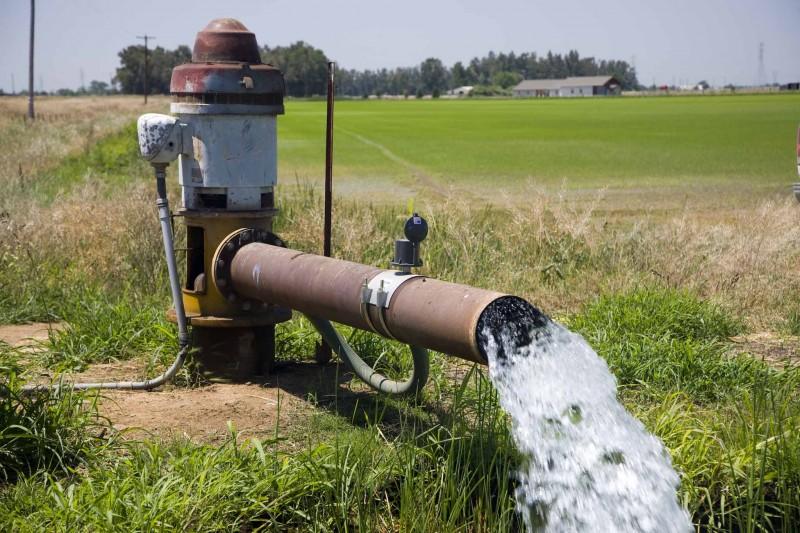
Groundwater comes mostly from snowmelt and rain percolating through soil and rock and from overland rivers, streams and other waterways. The infiltration is gradual, driven by gravity. Groundwater will flow toward rivers, lakes or the ocean to begin the cycle anew. Groundwater can be pumped or flow naturally to the surface through seepage or springs.

Groundwater can be thousands of years old, although typically it is pumped within years or decades after it originally moved underground through porous material called aquifers.

Aquifers can be several feet, or several thousand feet thick. California’s alluvial aquifers are composed of gravel, sand, silt and clay eroded from surrounding rocks and deposited by running water and wind.

California’s Underground Supply

Exactly how much water can be stored within California’s 515 alluvial groundwater basins and subbasins is unclear. The state Department of Water Resources (DWR) estimates their total storage capacity at more than 850 million acre-feet, more than 10 times that of all the state’s surface reservoirs. One acre-foot is enough to supply two to three households annually in California.

About 83 percent of Californians rely on groundwater for some portion of their water supply. The amount of groundwater used in a community’s water supply varies considerably, depending on the availability of surface water supplies and the cost to pump, treat and distribute groundwater.

California’s largest and most heavily used groundwater basins are in the Central Valley, where aquifers are generally permeable. DWR estimates as many as 2 million wells tap the underground supply.

Groundwater is also heavily used in the Salinas and Santa Clara valleys, the coastal plains of Los Angeles and Orange counties, and the interior basins of Riverside, San Bernardino and Inyo counties.

Interconnection with Surface Water

The state’s surface water and groundwater are intimately connected. Rivers and creeks are fed from groundwater, which, in turn, is recharged by surface water. Surface water diversions can deplete groundwater just as groundwater pumping can reduce the flows of nearby waterways.

Groundwater recharge project in Madera CountyPolluted surface water degrades groundwater and groundwater contaminants affect surface water quality. The use, transfer, depletion or contamination of one can directly affect the other.

Flood and furrow irrigation and unlined irrigation canals are important sources of groundwater recharge. Many factors affect the rate of rainwater absorption. The amount of water that reaches the water table is called natural groundwater recharge.

How much recharge occurs depends upon river conditions, the rate and duration of rainfall and irrigation, soil moisture, the water table depth, and the soil type. It generally takes several years of average precipitation to recharge aquifers in California to pre-drought levels.

The time it takes for infiltrating water to reach an aquifer as deep as 400 feet may take hours, days, or even years. In some flood-irrigated areas, groundwater levels in nearby domestic wells rise within a few hours to days of flooding.

Challenges

Some communities in Orange and Sonoma counties and elsewhere have figured out ways to better manage their groundwater. Other communities that have pumped too much groundwater wrestle with the consequences, including:

  • Land subsidence
  • Drying of wells
  • Reduced stream flows
  • Loss of wetlands and associated aquatic species
  • Seawater intrusion into coastal aquifers  

Some groundwater is polluted with natural elements leached from the earth, including chromium, radon, boron and arsenic. Other contamination comes from industrial and agricultural wastes in the form of synthetic pesticides, herbicides, fertilizers, cleaning solvents and fuel ingredients. [See also Nitrate Contamination and Groundwater Treatment.]

Land subsidence from groundwater pumping continues in many areas of California, some places at a rate of more than 1 foot a year. In the San Joaquin Valley, subsidence has damaged and slowed the conveyance of surface water through the California Aqueduct, Delta Mendota Canal, Friant-Kern Canal and San Luis Canal, as well as private canals, bridges, pipelines and storm sewers.

Management

Until recently, California did not regulate groundwater use beyond the general dictum of putting it to a “beneficial” use. [See Groundwater Law.] A new era of groundwater management began in 2014 when Gov. Jerry Brown signed the landmark Sustainable Groundwater Management Act (SGMA).

3-D maps of the Central Valley's underground The law empowers local officials to halt the trend of “critically overdrafted” or depleted basins. Under SGMA, high- and medium-priority groundwater basins were required to establish local Groundwater Sustainability Agencies to manage their basins or submit an alternative plan that meets the goals of the law.

Those agencies must create and adopt “sustainability” plans acceptable to state water regulators that halt overdraft in groundwater basins and bring pumping and recharge into balance. For critically overdrafted basins, balance must be achieved by 2040. High- and medium-priority basins must do so by 2042. Local sustainability plans began to be implemented in 2020.

Improving recharge is key to most plans and involves multiple steps –finding underground conditions that can best capture and store groundwater, building infrastructure to deliver the water, and having upstream storage to hold peak flows for replenishing aquifers. 

  • Print-friendly

Referring Pages

Share this page

  • Share on Facebook
  • Share on Twitter
  • Share on LinkedIn
  • Sent to a friend.
Print-friendly

Related Links

Aquapedia background February 3, 2014 California Groundwater Map Layperson's Guide to Groundwater
California Groundwater poster map
Maps & Posters May 20, 2014 Groundwater Education Bundle

California Groundwater Map
Redesigned in 2017

Fashioned after the popular California Water Map, this 24×36-inch poster was extensively re-designed in 2017 to better illustrate the value and use of groundwater in California, the main types of aquifers, and the connection between groundwater and surface water.

  • Read more
Publication May 20, 2014 California Groundwater Map

Layperson’s Guide to Groundwater
Updated 2017

The 28-page Layperson’s Guide to Groundwater is an in-depth, easy-to-understand publication that provides background and perspective on groundwater. The guide explains what groundwater is – not an underground network of rivers and lakes! – and the history of its use in California.

  • Read more
Back
This item appears in:
  • G
  • Topic: Groundwater
Footer pod May 20, 2014

Water Education Foundation

Copyright © 2025 Water Education Foundation. All rights reserved.

The Water Education Foundation is a nonprofit, tax-exempt, 501(c)3 organization, federal tax ID #942419885.

Privacy Policy

Donor Privacy Policy

  • Read more
Footer pod May 20, 2014

Contact Information

2151 River Plaza Drive, Suite 205
Sacramento CA 95833

Telephone (916) 444-6240

Contact Us via email

  • Read more

Quicklinks

Footer quicklink May 20, 2014

Contact Us

  • Read more
Footer quicklink May 20, 2014

Donate Today

  • Read more
Footer quicklink May 20, 2014

Tours

  • Read more
Footer quicklink May 20, 2014

Newsletter Signup

  • Read more
Footer quicklink May 20, 2014

Foundation News

  • Read more
Footer quicklink May 20, 2014

Calendar

  • Read more

Log in

  • Create new account
  • Request new password

Commands

  • Support portal
  • Log in