Header link June 22, 2020

LinkedIn

  • Read more
Header link September 15, 2014

Cart

  • Read more
Header link November 3, 2015

Donate Now

  • Read more
Header link May 15, 2014

Twitter

  • Read more
Header link May 15, 2014

Facebook

  • Read more
Instagram
Header link May 15, 2014

Instagram

  • Read more
Header link May 15, 2014

Contact Us

  • Read more
More options
Water Education Foundation
Home
Water Education Foundation
Everything about California water that matters
  • Water Academy
    • Agriculture
      • Agricultural Conservation
      • Agricultural Drainage
    • Background Information
      • Legislation — California and Federal
      • Regulations — California and Federal
      • Water History
      • Water Rights
    • Bay-Delta
      • Bay Delta
      • Bay Delta Conservation Plan
      • Delta Issues
      • Delta Smelt
      • Sacramento San Joaquin Delta
      • San Francisco Bay
      • Suisun Marsh
    • Dams, Reservoirs and Water Projects
      • California Aqueduct
      • Central Valley Project
      • Folsom Dam
      • Friant Dam
      • Hetch Hetchy
      • Hoover Dam
      • Infrastructure
      • Lake Mead
      • Lake Powell
      • Oroville Dam
      • San Luis Dam
      • Shasta Dam
      • State Water Project
    • Environmental Issues
      • Anadromous Fish Restoration
      • Ecosystem
      • Endangered Species Act
      • Invasive species
      • Lake Tahoe
      • Mono Lake
      • Public Trust Doctrine
      • Salmon
      • San Joaquin River Restoration
      • Watershed
      • Wetlands
    • Leaders and Experts
    • Regions
      • Central Coast
      • Central Valley
      • Mexico
      • Nevada
      • North Coast
      • Pyramid Lake
      • Sacramento Valley
      • Salton Sea
      • San Joaquin Valley
      • Sierra Nevada
      • Southern California
      • Tulare Lake Basin
    • Rivers
      • Carson River
      • Colorado River
      • Klamath River
      • New River
      • North Coast Rivers
      • Russian River
      • Sacramento River
      • Truckee River
      • San Joaquin River
    • Water Issues
      • Climate Change
      • Coronavirus
      • Drought
      • Earthquakes
      • Energy and Water
      • Floods
      • Fracking
      • Growth
      • Hydropower
      • Levees
      • Tribal Water Issues
      • Water Conservation
    • Water Quality
      • Drinking Water
      • Nitrate contamination
      • Pollution
      • Stormwater
      • Wastewater
      • Water Quality
    • Water Supply and Management
      • Acre Foot
      • Aquifers
      • California Water Plan
      • Conjunctive Use
      • Desalination
      • Grey water
      • Groundwater
      • Integrated Regional Water Management
      • Recreation
      • Surface Water
      • Water Marketing and Banking
      • Water Rates
      • Water Recycling
      • Water Supply
      • Water Transfers
  • Tours & Events
    • Water Tours
      • 2024 Tour Sponsors
    • Events
    • Event Calendar
    • Past Tours & Events
      • Anne J. Schneider Fund Lecture Series
  • Specialized Programs
    • Water Leaders
      • Cohort Rosters
      • Yearly Class Reports
      • Your Alumni Network
      • Alumni Profiles
    • Project WET
      • Workshops
      • Special Workshops & Events
      • Supplementary Materials
      • California Content Standard Correlations
      • Facilitator's Trainings
      • Foundation School Programs
        • Elementary Programs
        • Secondary Programs
      • Water Kids
      • California Project WET Gazette
      • Gazette Archives
    • Colorado River Project
    • GRA Scholastic Fund Program
  • Maps & Guides
    • Maps & Posters
    • Layperson's Guides
    • Map & Guide Bundles
    • Books
    • Colorado River Materials
    • California Runoff Rundown
    • Other Publications
    • Water Awareness Materials
    • Downloadable Publications
    • Videos and DVDs
      • Video Clips
    • School Age Publications
    • Stickers
    • Free Programs and Publications
  • Newsroom
    • Western Water News
    • Aquafornia
      • About Aquafornia
    • Information Desk
    • Western Water Magazine Archive
      • Full Print Edition
      • Print Edition Excerpts
    • River Report Archive
  • Aquapedia
    • Alphabetical List of Subjects
      • A
      • B
      • C
      • D
      • E
      • F
      • G
      • H
      • I
      • J
      • K
      • L
      • M
      • N
      • O
      • P
      • Q
      • R
      • S
      • T
      • U
      • V
      • W
      • X
      • Y
      • Z
    • Historical Water People
    • Where Does My Water Come From?
      • Northern California
      • Sacramento
      • North Bay
      • South Bay
      • Central Valley
      • Los Angeles
      • Inland Empire
      • San Diego
      • All California Water Sources
    • Timelines
    • Videos
    • Image Gallery
    • Water Directory
      • Federal Agencies
      • State Agencies in California
      • Environmental Organizations
      • Other California Organizations
      • State and Federal Legislative Committees
      • Water Associations and Groups
      • Western States Water Agencies and Districts
    • Online Resources
    • Useful Acronyms
    • About Aquapedia
  • About
    • About Us
      • Board of Directors
      • Staff Biographies
      • Job Openings
    • Announcements
    • Support Our Mission
      • Become a Member
      • Donate in Honor/Memory
      • Planned Giving
    • Contact Us
Aquapedia banner
Banner May 22, 2014

Your Online Water Encyclopedia

  • Read more

K

Overview February 10, 2014

K

  • Read more
Aquapedia background February 3, 2014

David N. Kennedy

David N. Kennedy (1936-2007) was at the helm as the director of the California Department of Water Resources (DWR) for 15 years, the longest serving director to date, and a champion of the State Water Project (SWP).

  • Read more
Aquapedia background February 10, 2014

Kesterson Reservoir

The former Kesterson Reservoir in the San Joaquin Valley provides a cautionary tale of the environmental impacts of agricultural drainage.

  • Read more
Aquapedia background February 10, 2014

Kings River

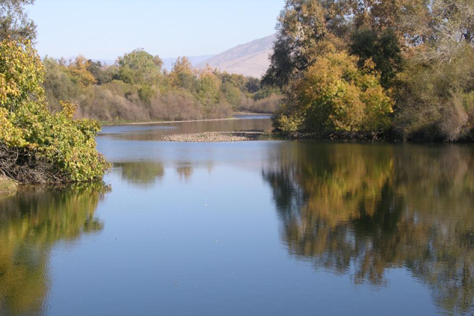
The 272-mile long Kings River drops sharply in elevation from its headwaters high in the Sierra Nevada Mountain Range on its way to the Central Valley, flowing just south-east of Fresno.

The dramatic descent generates electric power for dams and the river also helps irrigate cropland and provides fresh water to Central Valley communities.

  • Read more
Aquapedia background February 10, 2014

Klamath Basin Chinook and Coho Salmon

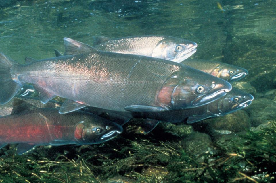
The Klamath Basin’s Chinook salmon and coho salmon serve a vital role in the watershed.

Together, they are key to the region’s water management, habitat restoration and fishing.

However, years of declining population have led to federally mandated salmon restoration plans—plans that complicate the diversion of Klamath water for agriculture and other uses.

  • Read more
 Klamath Basin Water Quality
Aquapedia background February 10, 2014

Klamath Basin Water Quality

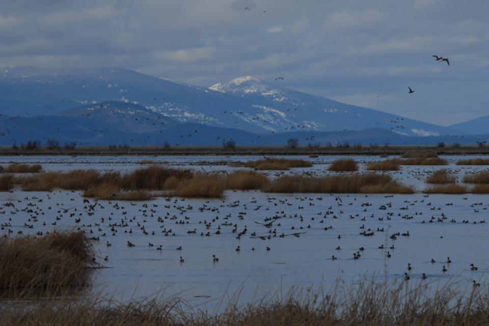
On the Klamath River, the Upper Klamath Basin’s aquatic ecosystems are naturally very productive due to its phosphorus-rich geology.

However, this high productivity makes the Basin’s lakes vulnerable to water quality problems.

Nutrient loads in the Upper Klamath Basin are a primary driver of water quality problems along the length of the Klamath River, including algal blooms in the Klamath Hydroelectric Project reservoirs. Municipal and industrial discharges of wastewater in the Klamath Falls area add to the nutrient load.

  • Read more
Cropland around Upper Klamath Lake in Oregon
Aquapedia background February 10, 2014 Layperson's Guide to the Klamath River Basin Klamath River Watershed Map

Klamath River Basin

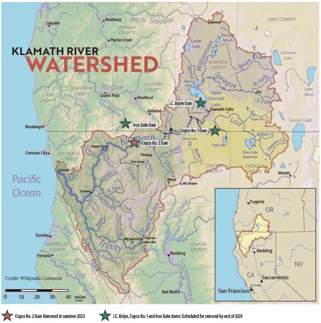
The Klamath River Basin is one of the West’s most important and contentious watersheds.

The watershed is known for its peculiar geography straddling California and Oregon. Unlike many western rivers, the Klamath does not originate in snowcapped mountains but rather on a volcanic plateau. 

A broad patchwork of spring-fed streams and rivers in south-central Oregon drains into Upper Klamath Lake and down into Lake Ewauna in the city of Klamath Falls. The outflow from Ewauna marks the beginning of the 263-mile Klamath River.

The Klamath courses south through the steep Cascade Range and west along the rugged Siskiyou Mountains to a redwood-lined estuary on the Pacific Ocean just south of Crescent City, draining a watershed of 10 million acres. 

A bounty of resources – water, salmon, timber and minerals – and a wide range of users turned the remote region into a hotspot for economic development and multiparty water disputes (See Klamath River timeline).

Though the basin has only 115,000 residents, there is seldom enough water to go around. Droughts are common. The water scarcity inflames tensions between agricultural, environmental and tribal interests, namely the basin’s four major tribes: the Klamath Tribes, the Karuk, Hoopa Valley and Yurok. Klamath water-use conflicts routinely spill into courtrooms, state legislatures and Congress. 

In 2023, a historic removal of four powers dams on the river began, signaling hope for restoration of the river and its fish and easing tensions between competing water interests. In February 2024, Interior Secretary Deb Haaland announced a “historic” agreement between tribes and farmers in the basin over chronic water shortages. The deal called for a wide range of river and creek restoration work and modernization of agricultural water supply infrastructure. 

Water Development

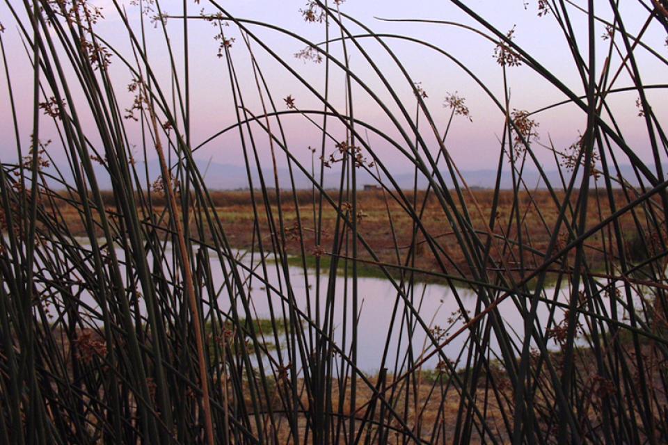
Farmers and ranchers have drawn irrigation water from basin rivers and lakes since the late 1900s. Vast wetlands around Upper Klamath Lake and upstream were drained to grow crops. Some wetlands have been restored, primarily for migratory birds.

In 1905, the federal government authorized construction of the Klamath Project, a network of irrigation canals, storage reservoirs and hydroelectric dams to grow an agricultural economy in the mostly dry Upper Basin. The Project managed by the U.S. Bureau of Reclamation irrigates about 240,000 acres and supplies the Lower Klamath Lake and Tule Lake national wildlife refuges managed by the U.S. Fish and Wildlife Service.

Klamath River Basin

Water Management

Since 1992, federal mandates to restore populations of fish protected by the Endangered Species Act have led in some dry years to drastic cuts in water deliveries to Klamath Project irrigators.

Water in Upper Klamath Lake must be kept above certain levels for the endangered shortnose and Lost River suckers. Lake levels and Klamath River flows below Iron Gate Dam also must be regulated for the benefit of threatened coho salmon (See Klamath Basin Chinook and Coho Salmon).

Conflict

In 2001, Reclamation all but cut off irrigation water to hundreds of basin farmers and ranchers, citing a severe drought and legal obligations to protect imperiled fish. In response, thousands of farmers, ranchers and residents flocked to downtown Klamath Falls to form a “bucket brigade” protest, emptying buckets of water into the closed irrigation canal. The demonstrations stretched into the summer, with protestors forcing open the irrigation headgates on multiple occasions. Reclamation later released some water to help farmers.

Karuk fisheries workers netting salmon in Klamath River.In September 2002, a catastrophic disease outbreak in the lower Klamath River killed tens of thousands of ocean-going salmon. The Pacific Coast Federation of Fishermen’s Associations sued Reclamation, alleging the Klamath Project’s irrigation deliveries had violated the Endangered Species Act. The fishing industry eventually prevailed, and a federal court ordered an increase to minimum flows in the lower Klamath.

Compromise

The massive salmon kill and dramatic water shut-off set in motion a sweeping compromise between the basin’s many competing water interests: the Klamath Basin Restoration Agreement and the Klamath Hydroelectric Settlement Agreement. The 2010 agreements included:

  • Removal of four hydroelectric dams
  • $92.5 million over 10 years to pay farmers to use less water, increase reservoir storage and help pay for water conservation and groundwater management projects.
  • $47 million over 10 years to buy or lease water rights to increase flows for salmon recovery.

Dam Removals

Congress never funded the two agreements, allowing the key provisions to expire. The restoration accord dissolved in 2016. The hydroelectric pact, however, was revived in an amended version that did not require federal legislation.

The new deal led to the nation’s largest dam removal project ever undertaken.

The Klamath's Copco No. 2 DamCalifornia and Oregon formed a nonprofit organization called the Klamath River Renewal Corporation to take control of the four essentially obsolete power dams – J.C. Boyle, Copco No. 1, Copco No. 2 and Iron Gate – and oversee a $450 million dam demolition and river restoration project.

Taking out the dams will open more than 420 miles of river and spawning streams that had been blocked for more than a century, including cold water pools salmon and trout need to survive the warming climate.  

Demolition crews took out the smallest dam in 2023 and the others were scheduled to come down by the end of 2024.

The images of yellow heavy machinery tearing into the dam’s spillway gates prompted a cathartic release for many who have been fighting for decades to open this stretch of the Klamath.

“I’m still in a little bit of shock,” said Toz Soto, the Karuk fisheries program manager. “This is actually happening…It’s kind of like the dog that finally caught the car, except we’re chasing dam removal.”

  • Read more
Aquapedia background February 10, 2014

Klamath River Basin Chronology

1849-1850 Gold discovered in the Lower Klamath Basin. Farms and ranches established in the Scott and Shasta valleys.

1855 Klamath River Reservation established on the Lower Klamath River.

1864 Hoopa Valley Tribe and Klamath Tribes cede most of their lands for settlement but retain large reservations.

1868 Two farmers dig first irrigation ditch in the Upper Klamath Basin.

  • Read more
Aquapedia background April 13, 2021

Lois Krieger

Lois Krieger (1917–2014) was one of the true pioneers of the California water world. She was the first woman elected chair of the Metropolitan Water District of Southern California’s board of directors, the first female president of the Association of California Water Agencies and a long-time champion of the wise development and use of water in the state.

  • Read more

Aquapedia

  • Alphabetical List of Subjects
    • A
    • B
    • C
    • D
    • E
    • F
    • G
    • H
    • I
    • J
    • K
    • L
    • M
    • N
    • O
    • P
    • Q
    • R
    • S
    • T
    • U
    • V
    • W
    • X
    • Y
    • Z
  • Historical Water People
  • Where Does My Water Come From?
  • Timelines
  • Videos
  • Image Gallery
  • Water Directory
  • Online Resources
  • Useful Acronyms
  • About Aquapedia
Footer pod May 20, 2014

Water Education Foundation

Copyright © 2025 Water Education Foundation. All rights reserved.

The Water Education Foundation is a nonprofit, tax-exempt, 501(c)3 organization, federal tax ID #942419885.

Privacy Policy

Donor Privacy Policy

  • Read more
Footer pod May 20, 2014

Contact Information

2151 River Plaza Drive, Suite 205
Sacramento CA 95833

Telephone (916) 444-6240

Contact Us via email

  • Read more

Quicklinks

Footer quicklink May 20, 2014

Contact Us

  • Read more
Footer quicklink May 20, 2014

Donate Today

  • Read more
Footer quicklink May 20, 2014

Tours

  • Read more
Footer quicklink May 20, 2014

Newsletter Signup

  • Read more
Footer quicklink May 20, 2014

Foundation News

  • Read more
Footer quicklink May 20, 2014

Calendar

  • Read more

Log in

  • Create new account
  • Request new password

Commands

  • Support portal
  • Log in