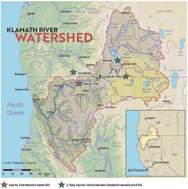
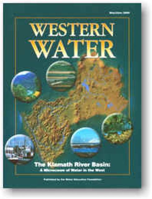
The Klamath River flows 253 miles
from Southern Oregon to the California coast, draining a basin of
more than 15,000 square miles. The watershed and its fisheries
have been the subject of negotiation since the 1860s negotiations
that have intensified and continue to this day.
The river has provided irrigation to ag lands since the late 19th
century. Agricultural development drained vast areas of
wetlands on the periphery of Upper Klamath Lake and in
upstream watersheds. Some of this drained acreage has been
restored and is now managed primarily for wetland benefits.
The watershed is divided geographically into two basins, upper
and lower, divided by Iron Gate Dam, the lower most dam on the
river. The Upper Basin is dry, with annual precipitation of about
13 inches at the river’s origin near Klamath Falls, Ore.
Downstream, the climate grows wetter.
Native Americans have a significant presence in the Klamath
Basin. Four major tribes have been influential in water
negotiations: the Klamath Tribes, the Karuk Tribe, the Hoopa
Valley Tribe and the Yurok Tribe.
On the afternoon of May 22, a wildfire sparked next to Highway
395 near the Mono Lake Tufa State Natural Reserve in the
Eastern Sierra Nevada, causing major damage to the reserve’s
infrastructure. The Inn Fire took off quickly, fueled by
high and erratic winds that caused it to jump across the
highway, where flames burned into the reserve.
… Officials are still assessing the extent of the damage
caused by the Inn Fire. One home burned down soon after the
fire ignited, and flames destroyed vegetation in the Inyo
National Forest, burning up toward the mountains. In the state
reserve, Jackson said flames burned into protected wetland
habitat and around the tufas. But the tufas are undamaged, she
noted. … The California State Parks Sierra District is
working with local land managers and other partners to plan how
to rebuild the boardwalk and the interpretative signs that were
lost in the fire.
… Last year, the final of four hydroelectric dams on the
Klamath River were removed in the largest project of its kind
in US history. Forged through the footprint of reservoirs that
kept parts of the Klamath submerged for more than a century,
the river that straddles the California-Oregon border has since
been reborn. The dam removal marked the end of a
decades-long campaign led by the Yurok, Karuk and Klamath
tribes, along with a wide range of environmental NGOs and
fishing advocacy groups, to convince owner PacifiCorp to let go
of the ageing infrastructure. The immense undertaking also
required buy-in from regulatory agencies, state and local
governments, businesses and the communities that used to live
along the shores of the bygone lakes. As the flows were
released and the river found its way back to itself, a new
chapter of recovery – complete with new challenges – emerged.
The Yurok Tribe, California’s largest federally recognized
tribal nation, was given 73 square miles of land — or
47,097 acres — along the eastern side of the lower Klamath
River on Thursday. The land exchange is being called the
largest single “land back” deal in California history. … The
73 square miles of land is now owned and managed by
the Yurok Tribe as the Blue Creek Salmon Sanctuary and
Yurok Tribal Community Forest. … These lands — comprising
forests, river corridors, and prairies — support essential
habitat for many imperiled species, including coho and Chinook
salmon, marbled murrelets, northern spotted owls, and Humboldt
martens. In the face of climate change, Blue Creek remains a
crucial cold-water refuge for salmon, steelhead, and other
native fish.
… Roughly 73 square miles (189 square kilometers) of
homelands have been returned to the Yurok, more than doubling
the tribe’s land holdings, according to a deal announced
Thursday. Completion of the land-back conservation deal along
the lower Klamath River — a partnership with
Western Rivers Conservancy and other environmental groups — is
being called the largest in California history. The Yurok
Tribe had 90% of its territory taken during the California Gold
Rush in the mid-1800s, suffering massacres and disease from
settlers. … The Yurok people will now manage these lands
and waterways. The tribe’s plans include reintroducing fire as
a forest management tool, clearing lands for prairie
restoration, removing invasive species and planting trees while
providing work for some of the tribe’s more than 5,000 members
and helping restoresalmon
and wildlife.
The First Descent Expedition of the Klamath River by young
members of Tribes living along the river will begin Thursday,
June 12. Participants in the Ríos to Rivers Paddle Tribal
Waters Program will lead the first-ever 30-day source-to-sea
descent of the newly undammed Klamath River. An opening
celebration marking the beginning of the month-long,
310-plus-miles expedition will be held June 12 at the
headwaters of the Wood River, an invitation-only event. From
the starting point, the kayakers will cross Upper Klamath Lake,
portage around the Link River Dam, and cross Lake Ewauna to the
Klamath River. … Organizers said the event will “explore
the long-awaited return of Chinook salmon to their ancestral
spawning grounds, the far-reaching benefits of dam removal and
the revival of an entire ecosystem. Experts will share
insights on water quality improvements, habitat restoration and
the lasting impacts on wildlife and river communities.”
A Placer County man is going to jail after the California
Department of Fish and Wildlife busted an illegal fish selling
operation. According to the CDFW, their Delta Bay Enhanced
Enforcement Program and Special Operations Unit investigated a
conspiracy to sell Pacific lamprey, leading to the arrest of
Justin D. Lewis. Lewis sourced Pacific lamprey, a California
state species of special concern, from the Klamath River in Del
Norte County and resold the fish to sellers across Colusa
County and beyond. The CDFW said lamprey are often used as bait
for sturgeon and other fish, but also are valued highly by the
Yurok tribe in Del Norte County as a food source and cultural
emblem. Lewis was sentenced on May 21 to two years — one
in the Colusa County Jail, and another on supervised release.
He also must pay more than $20,000 in fines and his fishing
privileges are suspended.
Recent cuts to the National Oceanic and Atmospheric
Administration (NOAA) have conservationists and scientists
worried about anadromous fish populations in the Pacific
Northwest. Like other federal agencies, NOAA is undergoing
major downsizing. The shrinkage is already disrupting habitat
restoration work for salmon and steelhead in California. And if
additional budget cuts that are currently in the works come to
fruition, the agency’s fisheries division could be eliminated
entirely, a recently retired NOAA scientist tells Field &
Stream. … When it comes to salmon and steelhead,
(fluvial geomorphologist Brian) Cluer worries most about
the potential loss of dam-removal projects in the Pacific
Northwest. NOAA played a pivotal role in the removal of four
dams on California’s Klamath River in 2023 and 2024, Cluer
says.
New public access sites have opened along the post-dam Klamath
River, allowing opportunities to enjoy the free-flowing river.
The largest dam removal project in U.S. history was completed
last year along the Klamath River. Proponents wanted the dams
gone to restore native salmon populations and important
cultural sites for the Shasta Indian Nation. But the undamming
project has also added new recreational opportunities on the
free-flowing river. Three sites opened this week in Oregon
and California, where visitors can put in boats, part of the
Klamath River Renewal Corporation’s recreation plan. American
Whitewater, a recreation advocacy group, has helped with the
process. … This week, the Pioneer Park West site opened
in Oregon. In California, the Copco Valley (K’utárawáx·u or ),
Fall Creek (K’účasčas) and Iron Gate locations have also
opened.
With the recent completion of dam removal along the
California-Oregon border, the public is being invited in to see
the results. A string of new recreation sites on
the Klamath River began opening Thursday, allowing
visitors to view and access the free-flowing waters that Native
Americans and environmentalists had long pushed to undam. The
five river access sites remain in various stages of
development. Three are debuting this week with pit toilets,
boat ramps, patches of riverfront and not much else. Improved
facilities are expected in coming months, providing sparse but
scenic spots for picnicking, wildlife viewing and
kayaking. Two of the sites are still under construction
and are closed. Managers of the dam-removal project expect all
the access areas to be fully open by August.
On Monday, AB 263 overwhelmingly passed the state Assembly. The
bill protects salmon populations in two key tributaries of the
Klamath River watershed by keeping minimum flow requirements in
place until the State Water Board can establish new long-term
flow regulations. The bill is now headed to the state Senate
for their consideration. … AB 263 was introduced in
partnership with the Karuk Tribe, California Coastkeeper
Alliance, and the Pacific Coast Federation of Fishermen’s
Association (PCFFA). The bill would maintain river flows
for at-risk salmon runs on two critical Klamath River
tributaries – the Scott and Shasta Rivers.
The Klamath River Renewal Corporation (KRRC) finished the
removal of the four lower Klamath hydroelectric dams in Fall
2024 and the dam removal portion of the Klamath River Renewal
Project is now complete. … As the reservoirs drained in
January 2024, native seed mix was applied to the reservoir
footprints. This initial round of seeding was intended to
stabilize sediments and improve soil composition. Following
reservoir drawdown, the newly exposed lands were planted with
more than 66,000 pounds of native seed, 77,000 bareroot, plug,
and container plants, and more than 25,000 acorns. … The
winter rain we received this year has provided ideal conditions
to flush additional sediments down river as well as promoting
the growth of native vegetation. Restoration crews are in the
field performing another round of seeding, planting and weeding
this spring.
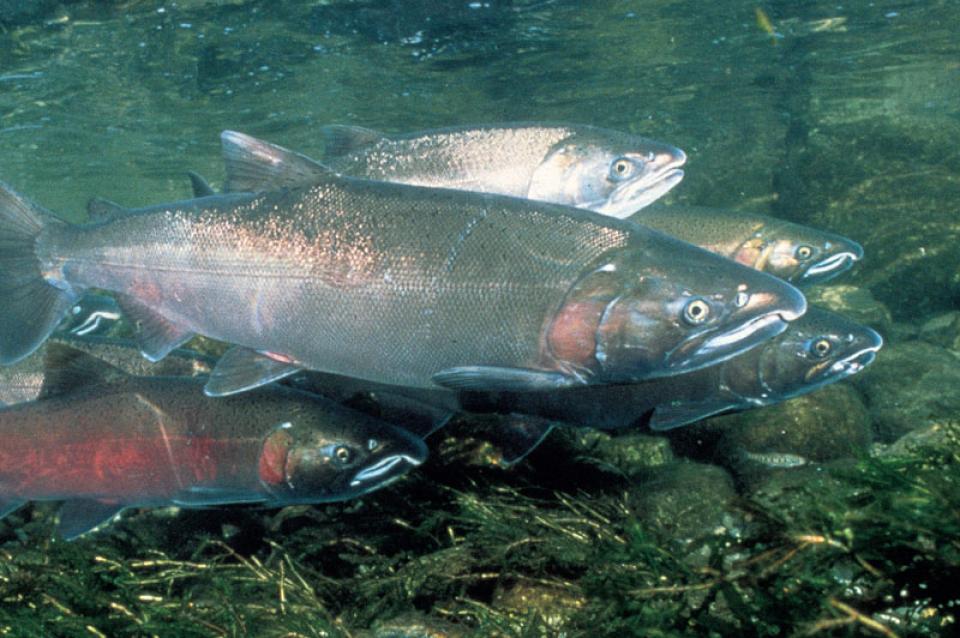
Last year, we watched as the last of four dams were removed
from the Klamath River in a historic endeavor. Karuk and Yurok
citizens sighed in relief, grateful that decades of tribal-led
activism, scientific research and litigation had succeeded in
reopening 400 stream miles of spawning habitat for salmon and
other species. The tears of joy came just a few weeks
later, when research cameras showed the first of more than
6,000 fish traveling past the first dam site. Spawning salmon
were crossing into Oregon’s Spencer Creek, a tributary of the
Klamath, for the first time in 112 years. The salmon had
remembered the way, for it is embedded into their DNA just as
it is in our ancestors’ – a testament of shared memory and
spiritual connection between our people and the river. –Written by Russell “Buster” Attebery, chairman of the
Karuk Tribe, and Joseph L. James, chairman of the Yurok
Tribe.
The Klamath River Fund, a program of Humboldt Area Foundation
and Wild Rivers Community Foundation (HAF+WRCF), today
announced $1.2 million in grants awarded to 12
organizations working across the Klamath Basin. These
grants mark a significant step in the Fund’s 10-year commitment
to invest in and amplify community-led climate resilience and
restorative justice efforts following the unprecedented removal
of four dams on the Klamath River in 2023 and 2024.
… The grants invest in a wide range of organizations and
projects including sustainable agriculture along the Sprague
River at the Klamath’s headwaters in Oregon to the first effort
to boat the length of the un-dammed Klamath by local Tribal
youth.
For the third consecutive year, commercial salmon fishing off
the California coast will be prohibited, although there will be
a limited opportunity for recreational anglers for the first
time since 2022. However, officials say data indicates the
industry could see a return in 2026. Angela Forristall, salmon
staff officer with the Pacific Fishery Management Council, said
the decision to recommend closing the state’s commercial salmon
fisheries for the year followed a challenging debate among the
council and stakeholders from both the recreational and
commercial fishing industries. Forristall shared that there
were several versions of the recommendation that did open
commercial fishing briefly, but the data they’re seeing from
populations in the Klamath and Sacramento rivers says it’s
potentially too soon for major operations.
*IMPORTANT* In anticipation of high demand, the Foundation will be allocating tickets via a lottery method with a maximum of 3 entrants per organization. To enter, please thoroughly review the tour details below so you’re fully aware of the time and financial commitments, then complete this entry form. Entrants selected via the ticket lottery will be contacted beginning on June 12 with an opportunity to register for the tour.
This special, first-ever Foundation water tour will not be offered every year! Join us as we examine water issues along the 263-mile Klamath River, from its spring-fed headwaters in south-central Oregon to its redwood-lined estuary on the Pacific Ocean in California.
Running Y Resort
5500 Running Y Rd
Klamath Falls, OR 97601
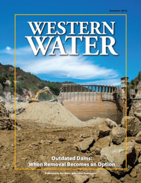
The dam removal projects- aimed at sustaining the salmon
population, are underway, with the latest drawdown being three
reservoirs on the Klamath River. The removal process has
already dramatically changed the landscape in Southern Oregon
and far Northern California, along the course of the river. The
lowest of the three remaining dams- Iron Gate, was initially
breached on January 9, followed by the J.C. Boyle reservoir on
January 16. A concrete plug in the tunnel at the base of Copco
1 was blasted away on January 23, with the reservoirs draining
quickly, leaving vast expanses of fissured mud that was the
consistency and color of chocolate cake batter. Shaping its new
course, the Klamath River is winding through the bare
landscape, but the transformation has had some unintended
consequences and saddened some residents.
…Tuesday, the State Water Resources Control Board took
action to protect the salmon,
unanimously extending the region’s
expired emergency drought measures. Ground and surface
water for farms will be restricted for another year if flows in
the Shasta and Scott rivers dip below minimum thresholds. State
officials say these measures are likely to kick in next
year. Water board chair Joaquin Esquivel said action
is needed because “a fish emergency” remains on the rivers.
“Time isn’t our friend,” he said at a previous meeting in
August. “There is an urgency.” The water board also
is investigating the possibility of permanent requirements to
keep more water in the rivers, after the Karuk Tribe and the
fishing industry petitioned the state for stronger protections.
That decision, however, could take years.
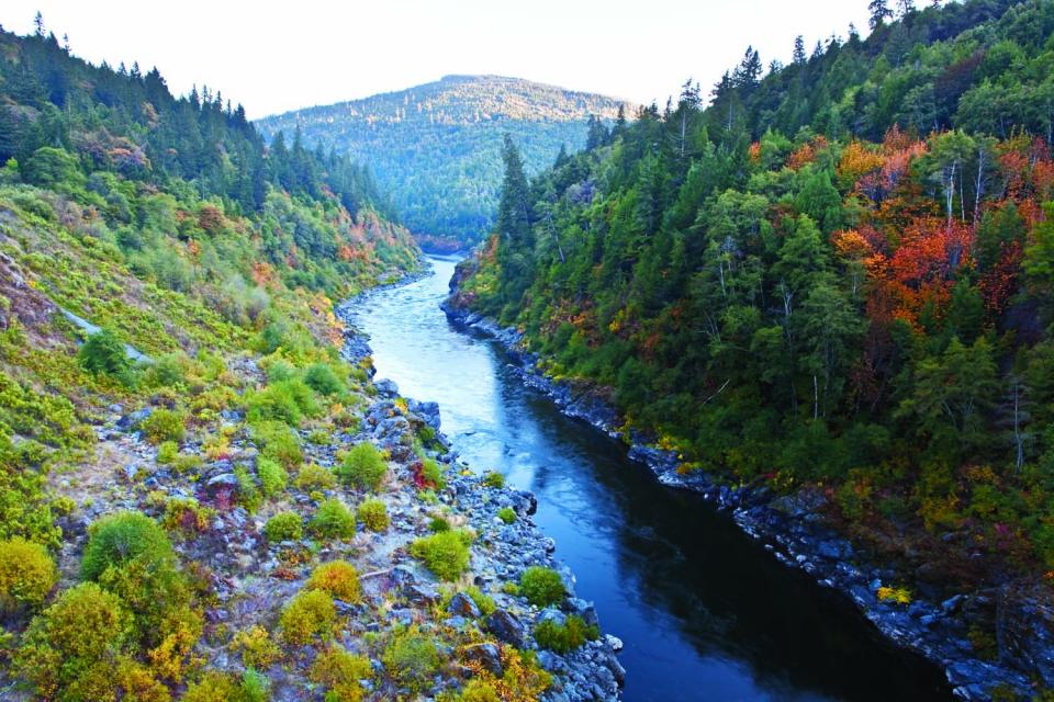
The Klamath River Basin was once one
of the world’s most ecologically magnificent regions, a watershed
teeming with salmon, migratory birds and wildlife that thrived
alongside Native American communities. The river flowed rapidly
from its headwaters in southern Oregon’s high deserts into Upper
Klamath Lake, collected snowmelt along a narrow gorge through the
Cascades, then raced downhill to the California coast in a misty,
redwood-lined finish.
California is chock full of rivers and creeks, yet the state’s network of stream gauges has significant gaps that limit real-time tracking of how much water is flowing downstream, information that is vital for flood protection, forecasting water supplies and knowing what the future might bring.
That network of stream gauges got a big boost Sept. 30 with the signing of SB 19. Authored by Sen. Bill Dodd (D-Napa), the law requires the state to develop a stream gauge deployment plan, focusing on reactivating existing gauges that have been offline for lack of funding and other reasons. Nearly half of California’s stream gauges are dormant.
In 1983, a landmark California Supreme Court ruling extended the public trust doctrine to tributary creeks that feed Mono Lake, which is a navigable water body even though the creeks themselves were not. The ruling marked a dramatic shift in water law and forced Los Angeles to cut back its take of water from those creeks in the Eastern Sierra to preserve the lake.
Now, a state appellate court has for the first time extended that same public trust doctrine to groundwater that feeds a navigable river, in this case the Scott River flowing through a picturesque valley of farms and alfalfa in Siskiyou County in the northern reaches of California.
Headwaters are the source of a
stream or river. They are located at the furthest point from
where the water body empties or merges with
another. Two-thirds of California’s surface water supply
originates in these mountainous and typically forested regions.
Mired in drought, expectations are high that new storage funded
by Prop. 1 will be constructed to help California weather the
adverse conditions and keep water flowing to homes and farms.
At the same time, there are some dams in the state eyed for
removal because they are obsolete – choked by accumulated
sediment, seismically vulnerable and out of compliance with
federal regulations that require environmental balance.
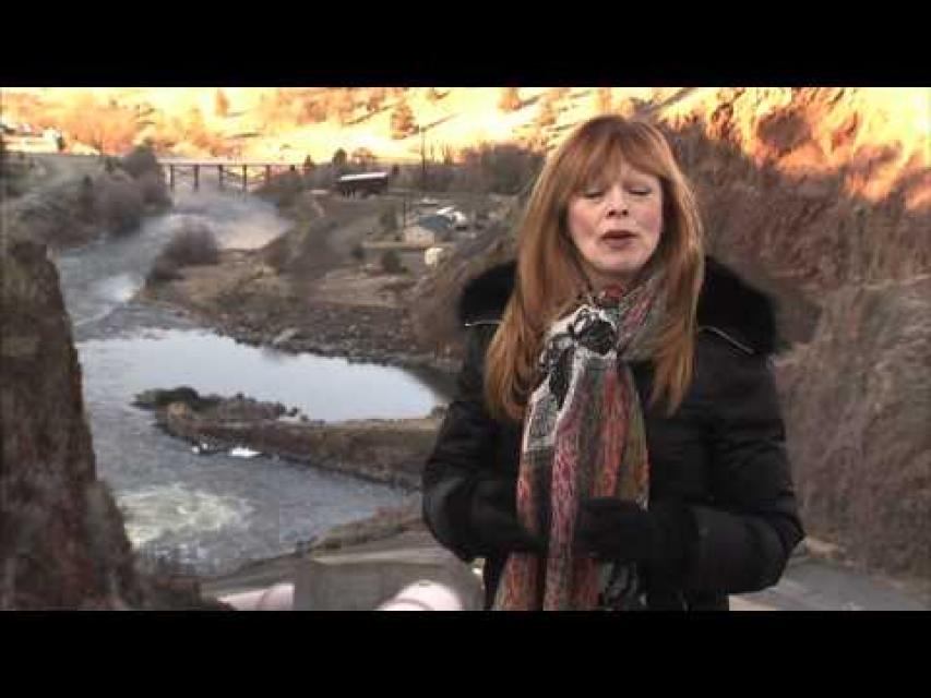
20-minute version of the 2012 documentary The Klamath Basin: A
Restoration for the Ages. This DVD is ideal for showing at
community forums and speaking engagements to help the public
understand the complex issues related to complex water management
disputes in the Klamath River Basin. Narrated by actress Frances
Fisher.
For over a century, the Klamath River Basin along the Oregon and
California border has faced complex water management disputes. As
relayed in this 2012, 60-minute public television documentary
narrated by actress Frances Fisher, the water interests range
from the Tribes near the river, to energy producer PacifiCorp,
farmers, municipalities, commercial fishermen, environmentalists
– all bearing legitimate arguments for how to manage the water.
After years of fighting, a groundbreaking compromise may soon
settle the battles with two epic agreements that hold the promise
of peace and fish for the watershed. View an excerpt from the
documentary here.
This 25-minute documentary-style DVD, developed in partnership
with the California Department of Water Resources, provides an
excellent overview of climate change and how it is already
affecting California. The DVD also explains what scientists
anticipate in the future related to sea level rise and
precipitation/runoff changes and explores the efforts that are
underway to plan and adapt to climate.
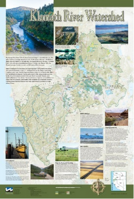
This beautiful 24×36-inch poster, suitable for framing, displays
the rivers, lakes and reservoirs, irrigated farmland, urban areas
and Indian reservations within the Klamath River Watershed. The
map text explains the many issues facing this vast,
15,000-square-mile watershed, including fish restoration;
agricultural water use; and wetlands. Also included are
descriptions of the separate, but linked, Klamath Basin
Restoration Agreement and the Klamath Hydroelectric Agreement,
and the next steps associated with those agreements. Development
of the map was funded by a grant from the U.S. Fish and Wildlife
Service.
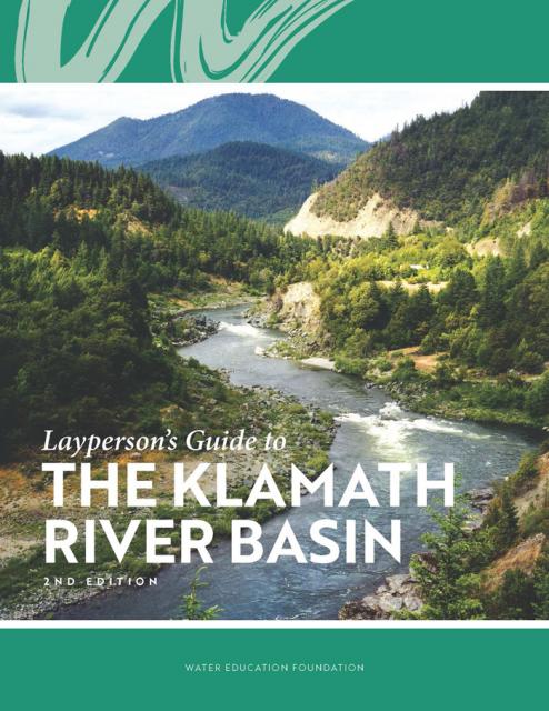
The Water Education Foundation’s second edition of
the Layperson’s Guide to The Klamath River Basin is
hot off the press and available for purchase.
Updated and redesigned, the easy-to-read overview covers the
history of the region’s tribal, agricultural and environmental
relationships with one of the West’s largest rivers — and a
vast watershed that hosts one of the nation’s oldest and
largest reclamation projects.
A new look for our most popular product! And it’s the perfect
gift for the water wonk in your life.
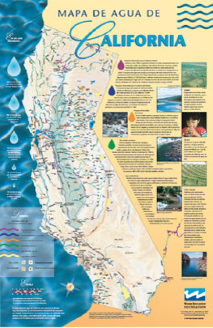
Our 24×36-inch California Water Map is widely known for being the
definitive poster that shows the integral role water plays in the
state. On this updated version, it is easier to see California’s
natural waterways and man-made reservoirs and aqueducts
– including federally, state and locally funded
projects – the wild and scenic rivers system, and
natural lakes. The map features beautiful photos of
California’s natural environment, rivers, water projects,
wildlife, and urban and agricultural uses and the
text focuses on key issues: water supply, water use, water
projects, the Delta, wild and scenic rivers and the Colorado
River.
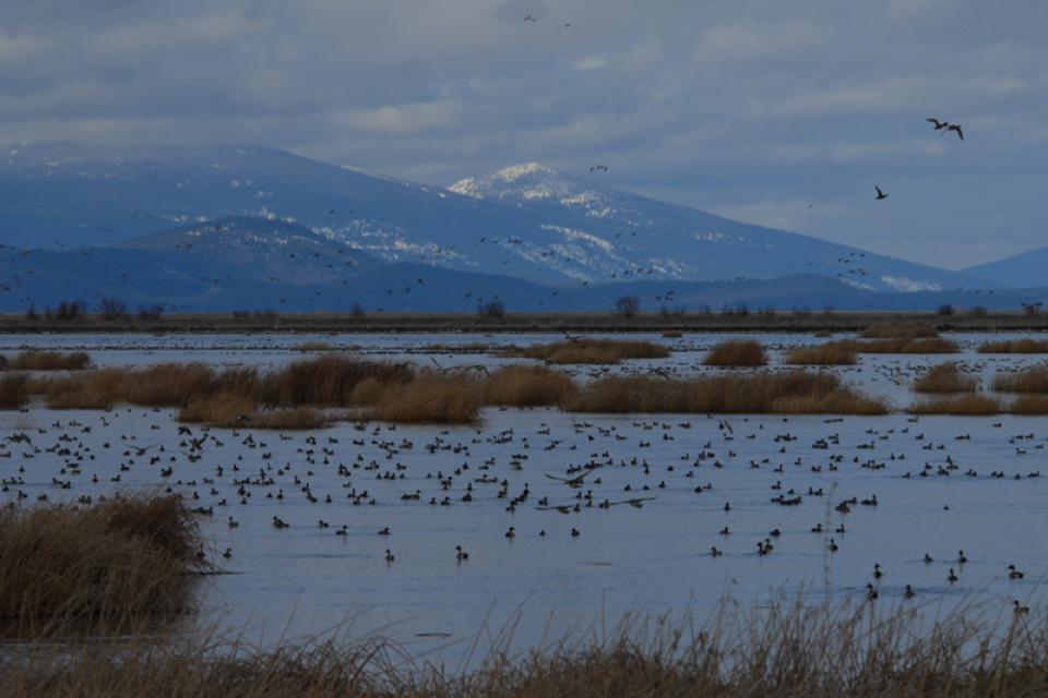
The Pacific Flyway is one of four
major North American migration routes for birds, especially
waterbirds, and stretches from Alaska in the north
to Patagonia in South America.
Each year, birds follow ancestral patterns as they travel the
flyway on their annual north-south migration. Along the way, they
need stopover sites such as wetlands with suitable habitat and
food supplies. In California, 95 percent of historic
wetlands have been lost, yet the Central Valley hosts some of the
world’s largest populations of wintering birds.
The Klamath River Basin is one of the West’s most important and
contentious watersheds.
The watershed is known for its peculiar geography straddling
California and Oregon. Unlike many western rivers, the
Klamath does not originate in snowcapped mountains but rather on
a volcanic plateau.
A broad patchwork of spring-fed streams and rivers in
south-central Oregon drains into Upper Klamath Lake and down into
Lake Ewauna in the city of Klamath Falls. The outflow from Ewauna
marks the beginning of the 263-mile Klamath River.
The Klamath courses south through the steep Cascade Range and
west along the rugged Siskiyou Mountains to a redwood-lined
estuary on the Pacific Ocean just south of Crescent City,
draining a watershed of 10 million acres.
A bounty of resources – water, salmon, timber and minerals – and
a wide range of users turned the remote region into a hotspot for
economic development and multiparty water disputes (See
Klamath River
timeline).
Though the basin has only 115,000 residents, there is seldom
enough water to go around. Droughts are common. The water
scarcity inflames tensions between agricultural,
environmental and tribal interests, namely the basin’s four major
tribes: the Klamath Tribes, the Karuk, Hoopa Valley and Yurok.
Klamath water-use conflicts routinely spill into courtrooms,
state legislatures and Congress.
In 2023, a historic removal of four powers dams on the river
began, signaling hope for restoration of the river and its fish
and easing tensions between competing water interests. In
February 2024, Interior Secretary Deb Haaland
announced a “historic” agreement between tribes and farmers
in the basin over chronic water shortages. The deal
called for a wide range of river and creek restoration work and
modernization of agricultural water supply infrastructure.
Water Development
Farmers and ranchers have drawn irrigation water from basin
rivers and lakes since the late 1900s. Vast wetlands around
Upper Klamath Lake and upstream were drained to grow crops. Some
wetlands have been restored, primarily for migratory birds.
In 1905, the federal government authorized construction of the
Klamath Project, a network of irrigation canals, storage
reservoirs and hydroelectric dams to grow an agricultural
economy in the mostly dry Upper Basin. The Project managed by the
U.S. Bureau of Reclamation irrigates about 240,000 acres and
supplies the Lower Klamath Lake and Tule Lake national wildlife
refuges managed by the U.S. Fish and Wildlife Service.
Water Management
Since 1992, federal mandates to restore populations of fish
protected by the Endangered Species
Act have led in some dry years to drastic cuts in
water deliveries to Klamath Project irrigators.
Water in Upper Klamath Lake must be kept above certain
levels for the endangered shortnose and Lost River suckers. Lake
levels and Klamath River flows below Iron Gate Dam also must be
regulated for the benefit of threatened coho salmon (See
Klamath Basin
Chinook and Coho Salmon).
Conflict
In 2001, Reclamation all but cut off irrigation water to hundreds
of basin farmers and ranchers, citing a severe drought and legal
obligations to protect imperiled fish. In response, thousands of
farmers, ranchers and residents flocked to downtown Klamath Falls
to form a “bucket brigade” protest, emptying buckets of water
into the closed irrigation canal. The demonstrations stretched
into the summer, with protestors forcing open the irrigation
headgates on multiple occasions. Reclamation later released some
water to help farmers.
In September 2002, a catastrophic
disease outbreak in the lower Klamath River killed tens of
thousands of ocean-going salmon. The Pacific Coast Federation of
Fishermen’s Associations sued Reclamation, alleging the Klamath
Project’s irrigation deliveries had violated the Endangered
Species Act. The fishing industry eventually prevailed, and
a federal court ordered an increase to minimum flows in the lower
Klamath.
Compromise
The massive salmon kill and dramatic water shut-off set in motion
a sweeping compromise between the basin’s many competing water
interests: the Klamath Basin Restoration Agreement and the
Klamath Hydroelectric Settlement Agreement. The 2010 agreements
included:
Removal of four hydroelectric dams
$92.5 million over 10 years to pay farmers to use less water,
increase reservoir storage and help pay for water conservation
and groundwater management projects.
$47 million over 10 years to buy or lease water rights to
increase flows for salmon recovery.
Dam Removals
Congress never funded the two agreements, allowing the key
provisions to expire. The restoration accord dissolved in 2016.
The hydroelectric pact, however, was revived in an amended
version that did not require federal legislation.
The new deal led to the nation’s largest dam removal project ever
undertaken.
California and Oregon formed a
nonprofit organization called the Klamath River Renewal
Corporation to take control of the four essentially obsolete
power dams – J.C. Boyle, Copco No. 1, Copco No. 2 and Iron Gate –
and oversee a $450 million dam demolition and river restoration
project.
Taking out the dams will open more than 420 miles of river and
spawning streams that had been blocked for more than a century,
including cold water pools salmon and trout need to survive the
warming climate.
Demolition crews took out the smallest dam in 2023 and the others
were scheduled to come down by the end of 2024.
The images of yellow heavy machinery tearing into the dam’s
spillway gates prompted a cathartic release for many who have
been fighting for decades to open this stretch of the Klamath.
“I’m still in a little bit of shock,” said Toz Soto,
the Karuk fisheries program manager. “This is actually
happening…It’s kind of like the dog that finally caught the car,
except we’re chasing dam removal.”
On the Klamath River, the Upper Klamath Basin’s aquatic
ecosystems are naturally very productive due to its
phosphorus-rich geology.
However, this high productivity makes the Basin’s lakes
vulnerable to water quality problems.
Nutrient loads in the Upper Klamath Basin are a primary driver of
water quality problems along the length of the Klamath River,
including algal blooms in the Klamath Hydroelectric Project
reservoirs. Municipal and industrial discharges of wastewater in
the Klamath Falls area add to the nutrient load.
The Klamath Basin’s Chinook salmon and coho salmon serve a vital
role in the watershed.
Together, they are key to the region’s water management, habitat
restoration and fishing.
However, years of declining population have led to federally
mandated salmon restoration plans—plans that complicate the
diversion of Klamath water for agriculture and other uses.
This issue of Western Water examines the challenges facing state,
federal and tribal officials and other stakeholders as they work
to manage terminal lakes. It includes background information on
the formation of these lakes, and overviews of the water quality,
habitat and political issues surrounding these distinctive bodies
of water. Much of the information in this article originated at
the September 2004 StateManagement Issues at Terminal Water
Bodies/Closed Basins conference.
The story of the Klamath River is the story of two basins.
In the upper basin, farming has long been the way of life. Even
before passage of the 1902 Reclamation Act, settlers had begun
the arduous process of reclaiming vast tracts of wetlands and
transforming them into rich farmland.


 and temperature. This gauge near downtown Sacramento measures water depth. (Source: California Department of Water Resources)")
")


. Credit: U.S. Bureau of Reclamation")