Summer 2023 California Project WET Gazette
Volume XXVlll, Issue IIl
High Water History
“Weather whiplash.” This term has become a favorite in weather-related articles and newscasts, but I don’t think any of us in California fully understood the meaning of it until the last six months. California’s Mediterranean climate is naturally erratic, but in recent years the swings have been dramatic.
The worst period of drought in at least 1,200 years was put on pause if not drowned by 31 atmospheric river events hitting the state since Dec. 31 and leaving behind one of the largest snowpacks since snow survey records began. And all that snow is beginning to melt with the onset of warmer temperatures.
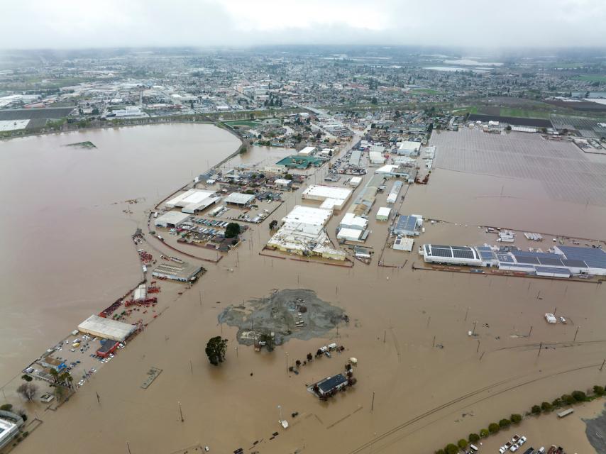 “High Water History” (p. 321) engages students in two of the most common questions people have when discussing a natural disaster like flooding: What are the odds of the event happening and how does one assess the toll on lives and property? But as many Californians know from recent or ongoing personal experience, the impacts of our extreme weather events and resulting flooding go well beyond calculations of event occurrence and property loss – as does the Project WET activity.
One of the activity extensions asks students to consider other kinds of weather-related aftermaths. In California, the fallout from this year’s series of atmospheric river events provides ample examples:
- The flooding that occurred throughout the state – and remains in the Tulare Basin
- The storm winds that downed power and toppled trees, damaging houses and vehicles statewide
- Roads washed out by stormwater, covered by landslides or undermined by sinkholes
- Homes hanging over eroded sea cliffs or crushed by heavy snow loads
- The toll on people with or without access to housing
Analyzing these examples and others provides a more complex and accurate understanding of the weather impacts.
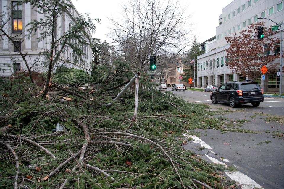 Another extension asks students to consider the longer-term outcomes of water-related disasters and their implications for people and the environment. As part of the “High Water History” activity, a class brainstorm on outcomes and implications of our early 2023 weather events would open the door to multiple avenues of study through multiple lenses and a variety of other Project WET activities.
Health: Mosquito and water-borne diseases are the focus of the activity “Super Sleuths” (p. 113) as many Central Valley communities brace for an expected surge in these diseases this summer due to the volume of standing water on the landscape. Updated components of the activity on the Portal include West Nile virus and how a changing climate may change the patterns of water-borne disease worldwide.
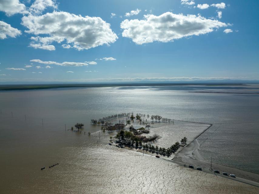 Politics: The model used in the Guide 1.0 activity “Whose Problem Is It?” provides a great framework for students to analyze the conflicting viewpoints that have played out in the Tulare Basin. The activity title alone pretty much sums up the very questions raised as floodwaters began pouring into the basin. Debates centered on allegations of cut levees, flood protection priorities and the role of federal, state and local government in preventing and managing the disaster.
Language Arts: “Nature Rules” (p: 277) has students diving deeper into the history of natural disasters in their community, investigating the effects of past weather events and decisions that influenced the outcomes. Students take on the role of reporters and write news articles based on their research, including interviewing people who have lived through natural disasters.
Social Studies: Educators have been using the activity “8-4-1, One for All” (p.299) to help students better understand the ripple effects of recent weather events on people and the environment. Students explore multiple viewpoints on water use challenges within a community, looking at how they affect eight different kinds of water users.
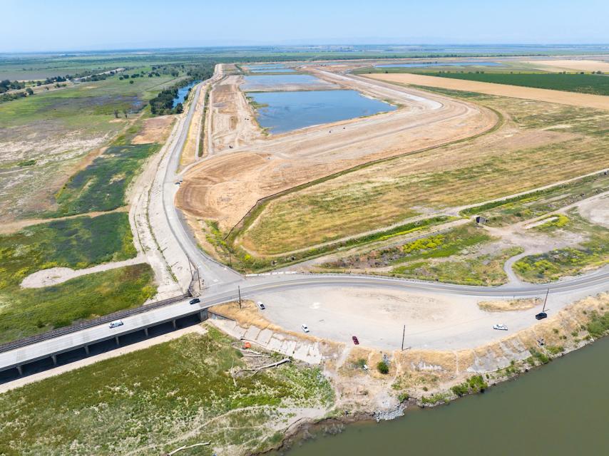 One of the most frequent questions or comments I’ve heard in workshops throughout this winter and spring pertains to what decision-makers and agencies are doing – or not doing – to protect communities and capitalize on the bounty of water we’ve received.* These perspectives can be integrated into “8-4-1, One for All” for students to explore and I’ve included a variety of articles in the Gazette’s Websites of Interest section to prime the pump.
STEAM: Of course, taking a deeper look into the impacts on people and their communities leads to an obvious question: What is being done or could be done now to reduce the risk of these impacts?
Applying what is learned to study local, real-life situations and potential solutions is at the core of Project WET activities. The Spring Gazette article, “Goldilocks & California Water Management,” also focused on learning from our winter storm events but emphasized decisions and solutions and less on people and their communities.
 Without an equal focus on the arts to humanize and effectively communicate issues, using the best science, technology, engineering and math may still not serve people and their communities well.
Please consider joining us this summer in one of the California Water Institutes for Teachers to learn more about the management of our state water resource systems and their tie to local water systems. You can also keep an eye out for Project WET workshops being planned for the fall. Those will explore California’s flood management system in the Central Valley, climate change and – yes – water conservation and why we all still need to do it.
I know it has been another tough year for many reading this and I hope everyone will be getting a chance for a much-needed break before diving into the next school year. Once you are feeling ready, please check out the upcoming “Summer Events” and “Professional Development Opportunities.” You’ll also find a variety of “Grants, Scholarships & Contests” to kick off the new school year in late summer through early fall. In the meantime, hope you all have a good summer!
*Among the most frequent comments are claims that water managers have “just been letting the water go to the ocean” without trying to capture any of it. Hydrograph data clearly show this is not the case for the state’s largest river, the Sacramento, and its largest tributary, the Feather. There were no major increases in stream flows at the U.S. Geological Survey gage on the Sacramento below Keswick Reservoir and the California Department of Water Resources gage on the Feather below Lake Oroville until both reservoirs were nearing capacity in late March and April. The U.S. Bureau of Reclamation posts monthly reports of inflows and releases online for all Central Valley Project reservoirs.
WEBSITES OF INTEREST
Article: Water whiplash: See how California’s drought disappeared in a few months
California has been on an amazing roller coaster of drought and floods recently. The three years from 2020 to 2022 were the driest three-year period in the state’s recorded history. But after a deluge this winter, reservoirs are full. Wildfire risk has dropped. Groundwater tables in many areas have risen. The Sierra snowpack, the source of 30% of California’s water supply, was at 324% of normal, the highest level in 40 years.
Many of California’s flood management systems were designed for the hydrological conditions of the previous century. California’s climate is changing with larger winter storms, more precipitation falling as rain rather than snow, and more extreme high tides. These changes, along with rising sea levels, will make many current flood management systems obsolete within decades, requiring major investments in new infrastructure and new approaches to reducing flood risk.
USGS: Floods and Recurrence Intervals
The USGS conducts research at locations around the United States and attempts to understand how the frequency of flooding changes with urbanization, climate variability, and other factors The term “100-year flood” is often used to describe a flood of great magnitude …. but what exactly is a “100-year flood”?
The state broke snowfall records after three of its driest years ever. Now floods wreak havoc. These swings are the new normal—and they’re very hard to manage. As climate change intensifies, extreme weather patterns are expected to continue and their unpredictability – intertwined in this delicate relationship are California’s ecosystems, agriculture industry, and communities.
ARTICLE: Why California’s floods may be ‘only a taste’ of what’s to come in a warmer world
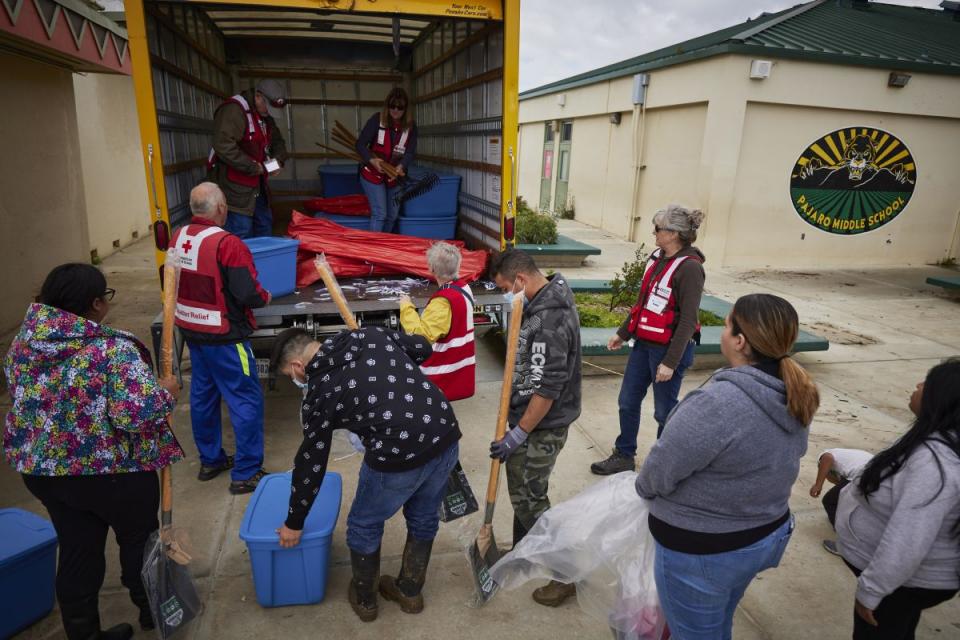
The street in front of Antonio Hueso’s two-story, yellow-daisy-colored home in Pajaro, about an hour south of San Francisco, turned into a deep muddy river in the early morning hours of March 12. The waters submerged his Ford F-150 truck and his first floor flooded. The levee failure forced more than 3,000 Pajaro residents to flee in the predawn darkness. Now, Hueso is beginning the arduous task of renovating his flood-damaged home.
Video: Managing California’s Water Through Climate Change Whiteboard Video
The State Water Contractors (SWC) is an association of 27 public water agencies and represents the legal, policy and regulatory interests of the State Water Project contractors, who are responsible for the capital and operations and maintenance costs of the SWP.
Yosemite Photos Show Park Flooding as Sierra Nevada Snow Melts
Photographs of California’s Yosemite National Park show the Merced River is overflowing as snow continues to melt. Yosemite has seen extreme flooding in recent weeks as warming temperatures melt the huge accumulation of snowpack in the Sierra Nevada.
California’s levee protection regulations are not uniform; the state’s seemingly endless dikes and causeways are overseen by a patchwork of widely varying rules. Some communities like Pajaro in Monterey County, which was swamped by floodwaters this year, are protected only against smaller storms that happen every eight years, while levees protecting urban areas of the Central Valley are bolstered against much more powerful storms.
Article: Return of a Lost Lake
A lost lake, long disappeared into the dirt, wows California by reappearing 40 years later. On the heels of the worst drought in 1,200 years, Tulare Lake, at the southern end of California’s San Joaquin Valley, filled and filled again in the heavy rains and runoff from its lower watershed, inundating over 100,000 acres of farmland, cities, and homes in the drought-dry lake bed between Fresno and Bakersfield.
Article: California’s farmers reeling as flooding wreaks havoc on dairy industry
Some of the country’s biggest farms operate in this region. Tulare, Kern and Kings counties are top-producing dairy counties in the state. The Tulare Lake basin’s vast farmland had suffered a severe drought, like most of California. Now floodwaters envelop it, looking like an inland sea when winds whip waves over swallowed houses, farms and rural Highway 43.
Article: Flood recovery goes beyond acreage
While flooding in California’s Salinas Valley region has had an economic impact, it has taken a personal toll as well. Not only were many farmworkers left without a job harvesting produce from fields, but some of these same laborers lost their homes. “Displaced housing is the single biggest issue by far,” said Christopher Valadez, president of the Grower-Shipper Association of Central California.
Article: Ugly Deeds, Politics, High Drama Swirl in Flood Waters of Tulare Lake
The drama was high on the Tulare Lake bed as flood waters pushed some landowners to resort to heavy-handed and, in one instance, illegal tactics, to try and keep their farm ground dry — even at the expense of other farmers and some small communities.
Article: How a Legacy of Racism Is Putting a 115-Year-Old Historically Black Town At Risk of Flooding — Again
Allensworth is a farmworker town where the tap water isn’t safe to drink. Many of its neighbors are large corporations and wealthy farmers, and these neighbors control many local agencies — like water and reclamation districts — which make decisions about who gets water in dry years and what to do when the floods come. The Tulare Lake basin also has a long history of levee sabotage.
Article: What return of Tulare Lake means for Yokut people of California
Robert Jeff had only heard of Tulare Lake in stories. But on a recent hot and windy afternoon, he looked out across soft ripples of water that seemed to go on forever. Jeff is vice chairman of the Tachi Yokut Tribe – one of about 50 bands of the Yokuts people that once built their lives around Tulare Lake, known to them as “Pa’ashi” – which means “big water.” Pa’ashi was an anchor of tribal life and spiritual beliefs.
Article: California triggers rarely used relief valve on Kern River, diverting flows to state aqueduct
The Kern River is swollen with so much runoff from the epic Sierra Nevada snowpack that officials have opened a rarely used relief valve, known as the Kern River Intertie, diverting floodwaters into the California Aqueduct to be used as drinking water in Southern California.
Article: California’s test: Can floodwater be captured and stored for future?
With concerns already high about drying water resources, recent storms and floods in the state have spurred fresh debate about whether a decades-old adaptation strategy – capturing and storing rain and snowmelt – could provide a sustainable solution in California, and across the nation. One solution to harnessing the resource could be the recharging of underground water systems.
Putting Flood Waters to Work: State Expedites Efforts to Maximize Groundwater Recharge
The Department of Water Resources (DWR) is implementing an emergency program to divert high river flows away from flood-prone Central Valley communities and into groundwater recharge basins. DWR is working with local agencies and equipment vendors to provide funding and secure much-needed temporary diversion equipment, including pumps and siphons, and will support their deployment by local agencies.
Article: High-Tech Mapping of Central Valley’s Underground Blazes Path to Drought Resilience
A new underground mapping technology that reveals the best spots for storing surplus water in California’s Central Valley. The maps provided by the California Department of Water Resources pinpoint paleo valleys and similar prime underground storage zones traditionally found with some guesswork by drilling exploratory wells and other more time-consuming manual methods.
The future of farming in California is changing as the planet warms, altering the rain and heat patterns that guide which crops are grown where. “We’re adjusting for survival,” one grower said. Hustling to adapt, farmers around the state are experimenting with new, more sustainable crops and varieties bred to better tolerate drought, heat, humidity and other elements of the increasingly unruly climate.
Article: Can retiring farmland make California’s Central Valley more equitable?
The West is not just facing an energy transition, it is also at the beginning of a major transition in land and water use. In California’s Central Valley, groundwater regulations will require retiring between 500,000 and 1 million acres by 2040.
Article: Why was your utility bill so high this past winter? Blame the drought — and California.
One explanation for this past winter’s soaring utility bills was the disruption in global natural gas supplies caused by the war in Ukraine, but it turns out the source of many Colorado households’ woes was closer to home: California. As the drought cut California’s hydropower production, the utilities in the state scrambled to buy natural gas, driving up costs across the West.
Article: Massive snowpack’s summer bonus: Clean, cheap electricity for California.
The huge snowpack that has blanketed the Sierra Nevada this winter has done more than end California’s drought and extend the ski season. It’s also changing how Californians keep the lights on. With reservoirs full across the state, hydroelectricity generation from dams is expected to expand dramatically this summer, after three dry years when it was badly hobbled.
Article: How Sierra Nevada snowpack confounds Central Valley groundwater readings
Billions of tons of snow piled atop the Sierra Nevada Mountains can cause parts of the Central Valley, just west of the range, to sink – muddling groundwater assessments that take sinking as a sign of depleted aquifers. A recent Stanford University study is now offering a way to account for this heavy mountain snowpack and more accurately gauge groundwater levels.
Article: Central Valley flooding offers birds bountiful water. Will it also poison them?
After struggling through years of punishing drought, California waterfowl and flocks of migrating birds are now enjoying a rare bounty of water as winter storms and spring snowmelt submerge vast tracts of Central Valley landscape. But even as birders celebrate the return of wet conditions along portions of the Pacific Flyway, experts worry that this liquid bonanza could ultimately poison tens of thousands of the avians as temperatures rise and newly formed lakes and ponds begin to evaporate.
Article: Two California lakes are making comebacks with different results
Some of California’s biggest lakes are making dramatic comebacks as the state’s “big melt” of snowpack reshapes the landscape in historic — and perhaps unexpected — ways. The return of Owens Lake threatens billions of dollars in efforts to stem air pollution, while the resurgent Mono Lake is generating cautious optimism.
USGS: Collecting water data for the U.S.
The USGS collects water data daily across the U.S. using sensors that automatically sample the data at set intervals. We have over 11,000 of these devices, known as gages, in our nationwide network. The data from these gages are used in decision-making at all levels, from recreationists to members of Congress.
California Department of Water Resources: Education
We provide a variety of resources to K-12 educators – including parents – to encourage water education in and out of the classroom. Our free supplementary materials can be used to help learn about California’s water resources. Check out our ‘Water Wednesdays’ YouTube page for recordings of our weekly conversations with DWR researchers on a range of water topics.
U.S. Geological Survey: Water Science School
Tap into over 140 years of USGS research in the natural sciences in the form of activities, maps, podcasts, online lectures, videos and more. Browse thousands of ideas for using these resources in elementary, secondary, university and informal education settings. Don’t forget to check out the USGS Water Science School loaded with great material for use with multiple Project WET activities!
PROFESSIONAL DEVELOPMENT OPPORTUNITIES
California Water Institutes for Teachers
These multi-day professional development experiences for K-12 teachers focus on the water infrastructure and supply that serve the local area of each institute while providing teachers with greater depth of knowledge and tools to engage students in learning about their local watersheds and development of their environmental literacy about the places where they live and recreate. Participants will also receive Project WET training, be able to earn continuing education credit and have an opportunity to receive a $300 stipend. Registration is still open for the Los Angeles and Solano Water Institutes!
Climate Change and California Water Workshops
These specialized Project WET workshops provide an opportunity for educators to interact with climate experts for a day of learning about the basics of weather and climate science, how the California Department of Water Resources and other organizations are applying this science to safeguard California water resources – and how Project WET activities can help you integrate climate science concepts and skills back in the classroom – Join us in Humboldt County this fall!
California Project Learning Tree Workshops
Project Learning Tree uses trees and forests as windows on the world to increase students’ understanding of the environment and actions they can take to conserve it. Trainings are offered to schools, teachers, parents, students and other non-profit organizations for outdoor environmental education programs.
California Project WET Workshops
Join us this fall for Project WET workshops focused on increasing your knowledge and environmental literacy through the lens of water, and how to use the interdisciplinary activities of Project WET to engage students K-12 in the study of water quality and conservation, climate change and water resources and the importance of reconnecting floodplains for flood protection, wildlife and multiple other benefits in a changing climate.
California Environmental Education Interagency Network (CEEIN)
The California Environmental Education Interagency Network (CEEIN) is a consortium of environmental educators representing state departments and partner organizations. The CEEIN partnership maintains an online calendar, where educators can find a variety of workshop experiences, participatory stewardship opportunities and valuable ways to increase their own knowledge and environmental literacy offered by California agencies and their partnership network.
SUMMER EVENTS
July 1 and September 2, 2023: California Free Fishing Days
Have you ever felt the excitement of watching your bobber suddenly jiggle, then dive out of sight? Or feeling the tap-tap-tap of a bass as it tastes the worm on the end of your line? CDFW offers two Free Fishing Days each year. On these days, you can fish without a sport fishing license. Free Fishing Days provide a great, low-cost way to give fishing a try.
August 25, 2023 - Free Entrance Days in the National Parks
Have you ever visited a national park and just thought, “Wow…” or “WOW!!!”? These special moments can happen very differently to each person visiting—so many “wow” moments happen in national parks happen every day. Well, it’s our birthday on August 25 and we want to celebrate those “wows” with you!
September 1 – 30, 2023 – National Preparedness Month
National Preparedness Month is an observance each September to raise awareness about the importance of preparing for disasters and emergencies — man-made or natural — that could affect them, their homes, communities, or businesses. This month aims to reduce the fallout of large-scale emergencies by preparing every citizen, young and old.
September 23, 2023 - California Coastal Cleanup Day
Join the fight to help clean the beach by picking up litter in your community. Trash travels through storm drains, creeks, and rivers to become beach and ocean pollution. Cleaning your neighborhoods, local parks, streets, and storm drains help protect our coast. Plan to spend a day outside connecting with your community to celebrate California! Click here for more information on how you and your students can participate!
September 22-24, 2023 - California Agriculture in the Classroom Conference
Join us in Sacramento – the Farm to Fork Capitol – for an invaluable opportunity to collaborate with educators who share your passion for agriculture! The CA AITC Conference is designed for K-12 educators, administrators and volunteers to come together to learn and share how to incorporate food and fiber into all curricular areas! Registration Cost (on or before August 15, 2023): $310 *Price will increase to $350 after August 15, 2023.
September 23, 2023 – National Public Lands Day
Join us for the 30th annual National Public Lands Day (NPLD)! NPLD is the nation’s largest single-day volunteer event for public lands. Established in 1994 and held annually on the fourth Saturday in September, this celebration brings out thousands of volunteers to help restore and improve public lands around the country.
September 23, 2023 - Free Entrance Days in the National Parks
NPLD is also a “Fee-Free Day”—one of only five days a year when entrance fees are waived at national parks and other public lands. Help care for your national parks by volunteering during a one-time event or on a reoccurring basis. It’s never too late to start planning!
GRANTS, SCHOLARSHIPS & CONTESTS
Forestry Challenge – Register Open: Fall 2023
The Forestry Challenge is an academic event for high school students in technical forestry and current forestry topics. Participants spend four days in the forest learning about the ecology and management of the forested landscapes that provide communities with water, recreational opportunities, wood products, and wildlife habitat. Pre-Registration for 2023 Fall Forestry Challenge events is now open! Thanks to new Grant Funding, Registration is now FREE!
Philanthropic Ventures Foundation Teacher Grants
Teachers come up with good ideas all the time but don’t have the resources to fund them or the time to pursue arduous funding requirements. That’s why we launched Teacher Resource Grants. These small but critically needed grants for teachers help to address inequalities in public education and build future generations of strong leaders.
“Let’s Go!” Field Trip Fund
Through the “Let’s Go!” Field Trip Fund, the Environmental Volunteers provides affordable, easy-to-schedule, efficient and safe transportation for low-income youth (K-12) in the San Francisco Bay Area (Alameda, Contra Costa, Marin, Napa, San Francisco, San Mateo, Santa Clara, Solano, or Sonoma) that facilitates access to science and environmental education field trips.
Salad Bars to Schools
Why salad bars? Supporting Research shows that incorporating salad bars into school lunches increases children’s consumption of fresh fruits and vegetables. Many school districts are unable to afford the basic equipment needed to adopt this strategy. SB2S is committed to helping schools make this positive change. We donate salad bars to schools so that every child across our nation has daily access to fresh fruits and vegetables.
Toshiba America Foundation K – 5 Grant - Deadline: October 1, 2023
Do you have an innovative idea for improving STEM learning in your classroom? Is your idea project-based learning with measurable outcomes? What do you need to make learning math and science fun for your students? K-5 grade teachers are invited to apply online for a $1,000 Toshiba America Foundation grant to help bring an innovative hands-on project into their own classroom.
Toshiba America Foundation 6 - 12 Grant - Deadline: November 1, 2023
Do you teach in a middle and high school classroom and have an innovative idea for improving STEM (Science, technology, engineering and math) learning in your classroom? Sixth to 12th-grade teachers are invited to apply online for a Toshiba America Foundation grant of up to $5,000 and more than $5,000 to help bring an innovative project into their own classroom.
CREDITS
California Project WET Gazette is published by the Water Education Foundation, which serves as the state coordinator and host institution for Project WET USA, a program of the Project WET Foundation.
This material is based upon work supported by the U.S. Geological Survey under Grant/Cooperative Agreement No. G21AC10429. The views and conclusions contained in this document are those of the authors and should not be interpreted as representing the opinions or policies of the U.S. Geological Survey. Mention of trade names or commercial products does not constitute their endorsement by the U.S. Geological Survey.
Editor: Brian Brown, California Project WET Coordinator
Water Education Foundation
2151 River Plaza Dr., Suite 205
Sacramento, CA 95833
916.444.6240
email: projectwet@watereducation.org


