Every snowflake or drop of rain that falls in Wyoming’s Wind
River Mountains eventually plays a part in quenching the water
needs of 20 million Californians, and the demand only seems to
be rising. Meanwhile, the amount of water available from the
Colorado River, which is partly fed by the Green River flowing
out of the Wind River range, is at best barely holding steady.
That means that as a headwaters state, Wyoming could start
feeling pressure from those downriver to give up more.
As the drought-strapped Colorado River struggled to feed water
into Lake Powell to keep its massive storage system and power
turbines from crashing in 2021 and 2022, the U.S. Bureau of
Reclamation, its operator, was scrambling to bring in extra
water from Flaming Gorge and Blue Mesa reservoirs. Since the
return of healthier flows in 2023, water levels in Flaming
Gorge and Blue Mesa have been restored, as required under a
2019 Colorado River Basin drought response plan. But the
subsequent shifting of water in 2023 to balance the contents of
lakes Powell and Mead, required under a set of operating
guidelines approved in 2007, resulted in an accidental release
of 40,000 acre-feet of water that will not be restored to the
Upper Basin because it is within the margin of error associated
with such balancing releases, according to Alex Pivarnik,
supervisory hydrologist with Reclamation’s Upper Colorado Basin
Region.
Several dozen dams throughout California could store up to 107
billion more gallons of water if they underwent repairs to fix
safety problems. But facing a staggering state deficit, Gov.
Gavin Newsom has proposed cutting funding for a dam repair
grant program in half this year, while state legislators want
the $50 million restored. California has an aging network
of nearly 1,540 dams — large and small, earthen and concrete —
that help store vital water supplies. For 42 of these dams,
state officials have restricted the amount of water that can be
stored behind them because safety deficiencies would raise the
risk to people downstream from earthquakes, storms or other
problems. Owned by cities, counties, utilities, water
districts and others, these dams have lost nearly 330,000
acre-feet of storage capacity because of the state’s safety
restrictions. That water — equivalent to the amount used by 3.6
million people for a year — could be used to supply
communities, farms or hydropower.
… All might be well in Lodi, but some other regions reported
cuts in their 2024 water supply. In the Westlands Water
District, which manages the water supply on the westside of
Fresno and Kings counties, a Westlands spokeswoman said the
agency was allocated less water than it had contracted for:
“[It’s] an incredibly disappointing and unjustifiably low
allocation for our district water users,” she said. How
is this possible, given the state’s historic rain and snow in
the 2023 water year and optimistic forecasts for the 2024 water
year? As of May 31, precipitation stood at 104% of normal for
the state, while major reservoirs are at 118% of normal,
according to figures compiled by California Water Watch.
The future of the Colorado River is in the hands of seven
people. They rarely appear together in public. [Last week],
they did just that – speaking on stage at a water law
conference at the University of Colorado, Boulder. The solution
to the Colorado River’s supply-demand imbalance will be
complicated. Their message in Boulder was simple: These things
take time. “We’re 30 months out,” said John Entsminger,
Nevada’s top water negotiator. “We’re very much in the second
or third inning of this baseball game that we’re playing here.”
The audience was mostly comprised of the people who will feel
the impact of their decisions most sharply – leaders from some
of the 30 Native American tribes that use Colorado River water,
nonprofit groups that advocate for the plants and animals
living along its banks, and managers of cities and farms that
depend on its flows.
The Department of the Interior announced a $700 million
investment in water conservation projects across the Lower
Colorado River Basin on Thursday that has the potential to save
more than 700,000 acre-feet of water in Lake Mead. The funds,
which come from the Inflation Reduction Act, will go toward
water distribution structures, farm efficiency improvements,
canal lining, turf removal, desalination, recycling water,
water purification and other projects, according to a statement
from the Department of the Interior.
A major project to build a new massive reservoir in Northern
California got a step closer to the start of construction, when
a judge rejected a lawsuit from environment groups that don’t
support the development, the California Gov. Gavin Newsom’s
office said Tuesday. The Yolo County Superior Court
approved the Sites Reservoir project within 148 days from when
the suit was filed, in part due to a new law signed
last year by Newsom to speed up the process to build
projects geared at meeting the state’s climate goals. The
court released its ruling on May 31.
The people who decide the fate of the Colorado River are
gathering in Boulder this week for an annual conference. Their
meeting comes at a pivotal time for negotiations on the river’s
future. Negotiators from all seven states that use the river
will be speaking publicly at the two-day conference. They’re in
the middle of tense talks about how to cut back on demand as
climate change is shrinking water supplies. They’ve got to come
up with new rules for sharing the river before the current
guidelines expire in 2026. … This week’s conference will also
feature speakers from tribes, cities and farm districts.
California is a semi-arid state in which the availability of
water determines land use, and in turn shapes the economy.
That, in a nutshell, explains why Californians have been
jousting over water for the state’s entire 174-year history.
The decades of what some have dubbed “water wars” may be
approaching a climactic point as climate change, economic
evolution, stagnant population growth and environmental
consciousness compel decisions on California’s water future. A
new study, conducted by researchers at three University of
California campuses, projects that a combination of factors
will reduce California’s water supply by up to 9 million
acre-feet a year – roughly the equivalent of all
non-agricultural human use. -Written by CalMatters columnist Dan Walters.
California is one step closer to building its largest water
storage facility in nearly 50 years, after a court ruled in
favor of the Sites Reservoir project following a challenge by
environmental groups. The Yolo County Superior Court issued the
65 page ruling late last week, marking a possible end to the
project’s environmental litigation. The relatively quick ruling
stands in contrast to a typical, multi-year litigation period
under the Environmental Quality Act (CEQA). Gov. Gavin Newsom
accelerated the project’s CEQA litigation period in November
under an infrastructure streamlining package passed the
previous summer. He celebrated the court’s ruling in a news
release Tuesday. … The proposed $4.5 billion reservoir would
inundate nearly 14,000 acres of ranch lands in Glenn and Colusa
counties to store water diverted from the Sacramento River
through new a system of dams, pipelines and a bridge.
Numerous lakes and reservoirs across the United States have
reached full capacity or near full capacity because of two
unusually wet winters. This resurgence in water levels is a
significant shift from the past few years when many regions
faced severe drought conditions. The map below shows all
the lakes currently at full capacity across the whole of the
U.S. These include several lakes that have been the subject of
great concern in recent years after prolonged drought
conditions. However, two wet winters in 2023 and this year,
have improved the outlook significantly, particularly in
California.
It’s not every day that a former source gets indicted. So when
a San Joaquin Valley water manager was charged by federal
prosecutors two years ago with allegedly stealing millions of
dollars worth of water for lavish personal gain, it stopped me
cold. It simply did not square with the person that I thought I
knew. Former general manager Dennis Falaschi of the Panoche
Water District ended up agreeing to a plea deal last week,
acknowledging that he stole some water and falsified some
income on a tax return. But upon any objective examination, the
deal is far more of a black eye to federal prosecutors than to
Falaschi himself because the feds had accused him of stealing
$25 million worth of water – more water than some California
cities use annually. The government utterly failed to prove
anything close to its original case. -Written by columnist Tom Philp.
The completion of Woodward Reservoir 114 years ago has been a
godsend to South San Joaquin Irrigation District as well as the
cities of Manteca, Lathrop, and Tracy. It has played a key role
as an in-district safety net to help SSJID to weather droughts
in much better shape than many other water purveyors in
California including Tri-Dam Project partner, the Oakdale
Irrigation District. The reservoir that holds 36,000 acre feet
of water or enough for just over three complete districtwide
irrigation runs is off stream as opposed to Tri-Dam reservoirs
at Goodwin, Tulloch, Beardsley, and Donnells as well as the
Bureau of Reclamation’s New Melones Reservior. New Melones
holds up to 600,000 acre feet for OID and SSJID as the
result of the original Melones Reservoir built by the two
districts being inundated to build it. -Written by Manteca Bulletin editor Dennis Wyatt.
After more than two decades, Lake Casitas, a vital water source
for the Ojai Valley and parts of Ventura County, has reached
full capacity, to the delight of California residents who lived
through the drought. Phone lines were buzzing Thursday at
Casitas Boat Rentals as the news spread that the lake is
currently at its fullest since 1998. “It’s a really good
feeling to know California is healing from all the drought
we’ve had,” says Kim Sanford of Ventura. … Just two
years ago, during the worst of the drought, the lake level
dropped to below 30 percent capacity. However, two rainy
winters have completely transformed the situation. The
Casitas Municipal Water District emphasizes that despite the
lake holding roughly a 20-year supply of water, conservation
remains a top priority.
“Planned export is 4,500 acre-feet”—that is the
much-anticipated decision from Los Angeles on water diversions
from the Mono Basin this year. This means Los Angeles
Department of Water & Power (DWP) diversions will not increase
from last year, even though existing rules would allow DWP to
quadruple their exports from the Mono Basin. This is good news
for Mono Lake, because the decision will help preserve the five
feet of recent wet year lake level gains. Thanks and credit for
this decision go to Los Angeles Mayor Karen Bass for her
leadership, city council and agency leaders, community leaders
for speaking up for environmental sustainability, and citywide
investment in water resilience such as stormwater capture and
other local water conservation measures. It follows a request
by the Mono Lake Committee and a diverse coalition of
supporters in March to not increase diversions.
Last year was notably wet, raising Mono Lake five feet—and
creating a conundrum. Under rules written three decades ago,
the lake’s rise over the 6,380-foot elevation threshold means
that on April 1, 2024, the maximum limit on water diversions
from Mono Lake increased nearly fourfold. Yet decades of
evidence show that increasing water diversions will erode the
wet year gains, stopping the lake from reaching the mandated
healthy 6,392-foot elevation. This flaw in the water
diversion rules, now obvious after 30 years of implementation,
has real-world results: Mono Lake is a decade late and eight
feet short of achieving the healthy lake requirement. The
California State Water Resources Control Board plans to examine
this problem in a future hearing.
A government agency that controls much of California’s water
supply released its initial allocation for 2021, and the
numbers reinforced fears that the state is falling into another
drought. The U.S. Bureau of Reclamation said Tuesday that most
of the water agencies that rely on the Central Valley Project
will get just 5% of their contract supply, a dismally low
number. Although the figure could grow if California gets more
rain and snow, the allocation comes amid fresh weather
forecasts suggesting the dry winter is continuing. The National
Weather Service says the Sacramento Valley will be warm and
windy the next few days, with no rain in the forecast.
The growing leadership of women in water. The Colorado River’s persistent drought and efforts to sign off on a plan to avert worse shortfalls of water from the river. And in California’s Central Valley, promising solutions to vexing water resource challenges.
These were among the topics that Western Water news explored in 2018.
We’re already planning a full slate of stories for 2019. You can sign up here to be alerted when new stories are published. In the meantime, take a look at what we dove into in 2018:
People in California and the
Southwest are getting stingier with water, a story that’s told by
the acre-foot.
For years, water use has generally been described in terms of
acre-foot per a certain number of households, keying off the
image of an acre-foot as a football field a foot deep in water.
The long-time rule of thumb: One acre-foot of water would supply
the indoor and outdoor needs of two typical urban households for
a year.
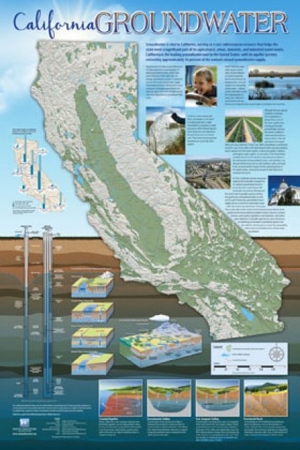
Fashioned after the popular California Water Map, this 24×36-inch
poster was extensively re-designed in 2017 to better illustrate
the value and use of groundwater in California, the main types of
aquifers, and the connection between groundwater and surface
water.
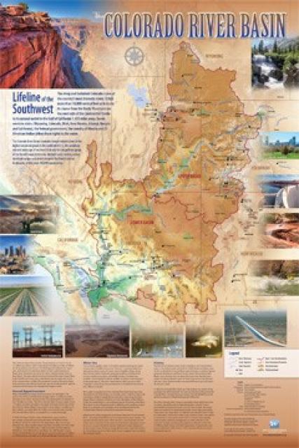
Redesigned in 2017, this beautiful map depicts the seven
Western states that share the Colorado River with Mexico. The
Colorado River supplies water to nearly 40 million people in
Arizona, California, Colorado, Nevada, New Mexico, Utah, Wyoming
and Mexico. Text on this beautiful, 24×36-inch map, which is
suitable for framing, explains the river’s apportionment, history
and the need to adapt its management for urban growth and
expected climate change impacts.
As the state’s population continues to grow and traditional water
supplies grow tighter, there is increased interest in reusing
treated wastewater for a variety of activities, including
irrigation of crops, parks and golf courses, groundwater recharge
and industrial uses.
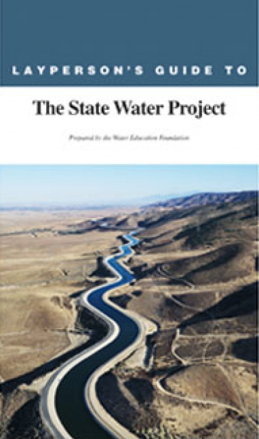
The 24-page Layperson’s Guide to the State Water Project provides
an overview of the California-funded and constructed State Water
Project.
The State Water Project is best known for the 444-mile-long
aqueduct that provides water from the Delta to San Joaquin Valley
agriculture and southern California cities. The guide contains
information about the project’s history and facilities.
The 24-page Layperson’s Guide to Integrated Regional Water
Management (IRWM) is an in-depth, easy-to-understand publication
that provides background information on the principles of IRWM,
its funding history and how it differs from the traditional water
management approach.
The 24-page Layperson’s Guide to Flood Management explains the
physical flood control system, including levees; discusses
previous flood events (including the 1997 flooding); explores
issues of floodplain management and development; provides an
overview of flood forecasting; and outlines ongoing flood control
projects.
The 24-page Layperson’s Guide to California Water provides an
excellent overview of the history of water development and use in
California. It includes sections on flood management; the state,
federal and Colorado River delivery systems; Delta issues; water
rights; environmental issues; water quality; and options for
stretching the water supply such as water marketing and
conjunctive use. New in this 10th edition of the guide is a
section on the human need for water.
The 24-page Layperson’s Guide to the Central Valley Project
explores the history and development of the federal Central
Valley Project (CVP), California’s largest surface water delivery
system. In addition to the project’s history, the guide describes
the various CVP facilities, CVP operations, the benefits the CVP
brought to the state and the CVP Improvement Act (CVPIA).
The 24-page Layperson’s Guide to the Delta explores the competing
uses and demands on California’s Sacramento-San Joaquin Delta.
Included in the guide are sections on the history of the Delta,
its role in the state’s water system, and its many complex issues
with sections on water quality, levees, salinity and agricultural
drainage, fish and wildlife, and water distribution.
A new look for our most popular product! And it’s the perfect
gift for the water wonk in your life.
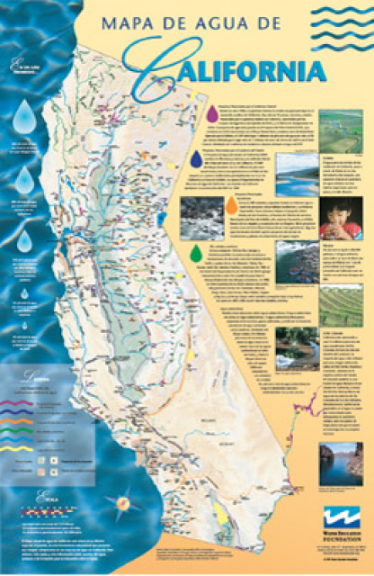
Our 24×36-inch California Water Map is widely known for being the
definitive poster that shows the integral role water plays in the
state. On this updated version, it is easier to see California’s
natural waterways and man-made reservoirs and aqueducts
– including federally, state and locally funded
projects – the wild and scenic rivers system, and
natural lakes. The map features beautiful photos of
California’s natural environment, rivers, water projects,
wildlife, and urban and agricultural uses and the
text focuses on key issues: water supply, water use, water
projects, the Delta, wild and scenic rivers and the Colorado
River.
An acre-foot is a common way in the U.S. to measure water volume
and use. It is the amount of water it takes to cover an acre of
land one foot deep. An acre is about the size of a football
field.
An acre-foot of water equals 325,851 gallons, and historically
that was enough to serve the needs of two families for a
year in California.
This printed issue of Western Water examines
agricultural water use – its successes, the planned state
regulation to quantify its efficiency and the potential for
greater savings.
This issue updates progress on crafting and implementing
California’s 4.4 plan to reduce its use of Colorado River water
by 800,000 acre-feet. The state has used as much as 5.2 million
acre-feet of Colorado River water annually, but under pressure
from Interior Secretary Bruce Babbitt and the other six states
that share this resource, California’s Colorado River parties
have been trying to close the gap between demand and supply.