Watershed
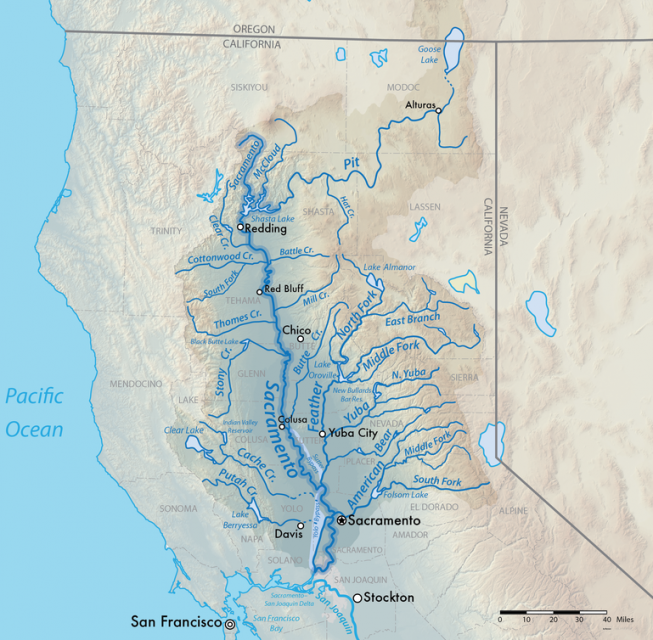
A watershed is the land area that drains snowmelt and rain into a network of lakes, streams, rivers and other waterways. It typically is identified by the largest draining watercourse within the system. In California, for example, the Sacramento River Basin is the state’s largest watershed.
Watersheds follow natural boundaries and are usually separated by ridges, canyons or mountains. A watershed has many important natural functions. It collects water from precipitation, stores groundwater in aquifers, releases water as runoff and provides habitat for plants and animals.
Though a natural part of the ecosystem, wildfires have become a major threat to watersheds in California and the West. A 2023 study of the region found that the climate-driven increase in wildfire danger and intensity is greatest above 9,800 feet, at the top of forested watersheds.
Major wildfires destroy vegetation, diminishing the ability of the soil to absorb stormwater runoff. Severe, slow-moving fires can leave a waxy coating on the soil, causing it to repel water like rain on pavement.
Areas downhill and downstream of burned areas are highly susceptible to flash flooding and mudslides, especially near steep terrain. Debris and pollutants can fill waterways.
The U.S. Forest Service, which manages nearly half of the land in California, is changing traditional forest management practices – incorporating more tree thinning and prescribed burns – to prevent post-fire erosion.
Watersheds may be as small as a patch of land draining into a tiny pond or as large as the Sacramento River Basin, which drains 27,000 square miles in Northern California. Drawn from the eastern slopes of the Coast Range and the western slopes of the southern Cascades and northern Sierra Nevada, the river carries 31 percent of the state’s water runoff, according to the Sacramento River Watershed Program.
Watch this video to learn more about restoration efforts on the San Joaquin River.
To the south, the 300-mile San Joaquin River drains a 16,000-square-mile basin. With headwaters in the southern Sierra Nevada, the San Joaquin runs down the western slope, as do the Stanislaus, Tuolumne and Merced rivers that join the lower San Joaquin River. The river then flows northwest where it meets the Sacramento River at the Sacramento-San Joaquin Delta, a 1,000-square-mile maze of channels and islands that drains more than 40 percent of the state’s lands.
Southern California’s Santa Ana River is the largest watershed south of the Sierra. About 100 miles long with more than 50 tributaries, the Santa Ana spans highly urbanized parts of San Bernardino, Riverside and Orange counties as it drains 2,840 square miles of land.


