Floodplains in California
With the dual threats of aging levees and anticipated rising sea levels, floodplains — low areas along waterways that flood during wet years — are increasingly at the forefront of many public policy and water issues in California.
Adding to the challenges, many floodplains have been heavily developed and are home to major cities such as Sacramento. Large parts of California’s valleys are historic floodplains as well.
Despite levees and upstream dams, floods in these areas have caused billions of dollars in damage.
Farming, urban construction and flood control projects have removed virtually all of the historic riparian and floodplain habitat in the Central Valley and Sacramento-San Joaquin Delta.
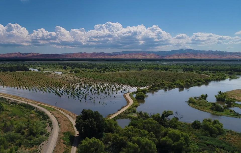
Several floodplains in California are being restored to create wildlife habitat, improve water quality by flushing out contaminants and replenish groundwater.
On the Yolo Bypass, just northwest of Sacramento, for example, work to adjust or move levees is now underway and, when completed, will allow more water to flood the area more frequently. This will create important habitat for small fish – notably Chinook salmon smolts – while reducing the threat of damaging floods in communities downstream. Similar landscape modifications are underway or have been completed throughout the Central Valley.
At the Dos Rios Ranch Preserve near Modesto, crews with the statewide conservation nonprofit River Partners have set back levees along eight miles of the San Joaquin and Tuolumne rivers to invite seasonal flooding.
Responding to Floodplain Challenges
Regular homeowner insurance typically does not cover flooding. The National Flood Insurance Act of 1968 allows property owners to buy flood insurance, however, insurance providers do not always offer flood protection to property owners in at-risk communities.
 The Federal Emergency Management
Agency (FEMA) is required by law to map the nation’s flood-prone
areas and establish flood-risk zones. Local governments decide
whether to allow development in floodplains.
In California, questions arose about the adequacy of a FEMA 100-year flood designation (1 percent chance a flood will occur annually) in the Central Valley after floods in 1997. Critics said the maps did not adequately depict areas reasonably likely to flood nor account for the runoff of upstream development.
The state Legislative Analyst’s Office noted in 2005 that while the Department of Water Resources estimates at least 50,000 of the state’s 200,000 miles of streams will likely see development during the next 20 years, FEMA has mapped only 15,000 miles in the past 30 years. The state has attempted to fill the gap through its own mapping program.
Floodplains in Sacramento
Flood mapping has particularly been the target of discussion in flood-prone Sacramento. The California capital is also considered one of the most at-risk cities for a major flood in the United States.
Following severe floods in the Sacramento area in 1986, the U.S. Army Corps of Engineers reassessed the adequacy of the local levee system and estimated that a 100-year flood along the American River floodplain could cause up to $15 billion in damages and cost as many as 100 lives.
FEMA then mapped most of Sacramento into the 100-year floodplain in 1989. Much of the now heavily developed Natomas area, consisting of 86 square miles of land near the Sacramento International Airport, was also included in the revised FEMA floodplain.
Other projects to repair levee seepage and erosion allowed the Corps to certify most of the remainder of Sacramento’s levees for 100-year protection.
After Natomas was deemed high risk in 2006, a levee protection program was launched. The Natomas Levee Improvement Program aims to provide at least 100-year flood protection and lay the groundwork for 200-year flood protection. Such efforts would significantly reduce the risk of an uncontrolled flood, one with estimated costs of $7 billion. Such flooding could also disrupt operation of the Sacramento International Airport and close Interstate 5 and State Route 99.
Meanwhile, Sacramento Area Flood Control Agency and the Corps have worked with the state to restore 100-year flood protection for most of the Sacramento urban area. More than $460 million has been spent on levee improvements.
And in 2012, West Sacramento, addressing an ongoing problem with under seepage, completed a $27 million project to reconstruct more than 8,000 feet of levees.
Floodplains and the Central Valley
California’s Department of Water Resources has a Central Valley Flood Protection Plan, a crucial first step in re-assessing how floods are channeled through the Sacramento-San Joaquin river systems. The 25-year, $17 billion blueprint includes the acquisition of up to 40,000 acres of land to accommodate flood waters as they drain from the Sacramento and San Joaquin river watersheds.
Sacramento benefits from the Yolo Bypass west of the city, where flood waters from the Sacramento River are funneled. About 100 miles upstream from the city on the Sacramento River, the Hamilton City Flood Damage Reduction and Ecosystem Restoration Project features seven miles of setback levee to improve flood protection for Hamilton City and restoration of about 1,500 acres to native habitat.
Updated June 2024


