Central Valley Project
 Birthed in the midst of the Great
Depression, the Central Valley Project today is one of the
largest water storage and transport systems in the world. In
years of normal precipitation, it stores and distributes about 20
percent of the state’s developed water through its massive system
of reservoirs and canals.
Birthed in the midst of the Great
Depression, the Central Valley Project today is one of the
largest water storage and transport systems in the world. In
years of normal precipitation, it stores and distributes about 20
percent of the state’s developed water through its massive system
of reservoirs and canals.
The CVP spans 450 miles from Shasta Lake in Northern California to Bakersfield in the southern San Joaquin Valley. Drawing mainly from the Sacramento and the San Joaquin river basins, the CVP features 20 dams and reservoirs along with numerous components of water storage and conveyance infrastructure.
The largest federal water project in the country, the CVP features a combined storage capacity of 11 million acre-feet, 11 power plants and three fish hatcheries. On the San Joaquin Valley’s east side, the CVP’s Friant Division serves about 15,000 farms on more than 1.5 million acres of land and supplies several cities, including Fresno.
In an average year, the CVP delivers more than 7 million acre-feet of water to farms, cities and the environment. About 75 percent of CVP water is used for agricultural irrigation that supports seven of California’s top 10 agricultural counties. The CVP’s hydroelectric power plants generate about 4.5 billion kilowatt-hours of electricity in an average year, which is approximately equivalent to the annual residential needs of about 1.5 million people. The CVP also dedicates up to 800,000 acre-feet per year to fish and wildlife habitat.
More broadly, the CVP’s benefits touch the lives of anyone who buys grapes, lettuce, almonds, canned tomatoes or a cotton shirt made from Central Valley crops. Because of the CVP and California’s State Water Project (SWP), the Central Valley has become the richest agricultural region in the nation. The widespread availability of water and hydroelectric power also has created millions of jobs and yielded untold billions in manufacturing and commerce.
The CVP’s major redistribution of water, however, has not occurred without controversy. Most of the CVP’s major facilities were constructed before the advent of federal environmental and resource laws, such as the Endangered Species Act and the National Environmental Policy Act. Conflicts have long festered over the project’s effect on the environment as well as its public costs and private benefits.
BACKGROUND
The CVP got its start in 1933 as a state-funded project to manage flooding, produce electricity, store and move water and help address groundwater depletion in the San Joaquin Valley. But in the depths of the Great Depression, California was unable to sell voter-approved bonds and attempts to obtain federal grants and loans failed. In 1935, the federal government, looking for projects that would create jobs, agreed to take it over.
The CVP is run by the U.S Bureau of Reclamation (Reclamation), a branch of the U.S. Department of the Interior that was created in 1902 to develop water resources in the West, primarily for agricultural use.
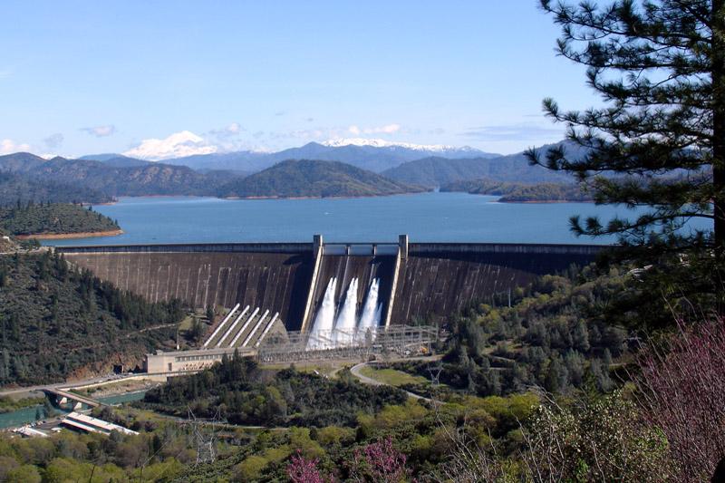
The CVP’s keystone, Shasta Dam, was built on the Sacramento River near Redding between 1938 and 1945 and created Shasta Lake, the largest reservoir in California. It was followed closely by Friant Dam, built between 1939 and 1942 on the San Joaquin River near Fresno to serve farms on the east side of the San Joaquin Valley. Other major CVP facilities include Trinity Dam on the Trinity River and Folsom Dam and reservoir on the American River near Sacramento. A joint federal-state “offstream” storage facility called San Luis Reservoir, south of the Delta near the town of Los Banos, is used for storage of water exported from the Delta prior to delivery to contractors on the west side of the San Joaquin Valley and in Silicon Valley. The Delta-Mendota Canal/California Aqueduct Intertie Project connects the federal system with the State Water Project.
Learn more about the history of the Central Valley Project in this video.
Various legal and financial aspects of the CVP and the law that governs its operation have been controversial. The CVP and other federally funded projects created a subsidy in the form of interest-free capital repayment in the water rates for irrigation users. The Reclamation Act of 1902, which created the Bureau of Reclamation, included a provision limiting this low-cost water to farmers who owned 160 acres or fewer. Long opposed by farmers, the limit on allowable acreage was increased to 960 acres by the Reclamation Reform Act of 1982.
The federal government has financed nearly all construction costs on most CVP projects, and state and local agencies are providing reimbursement of costs over several decades.
As a result of a 2016 change in federal law, the Bureau of Reclamation allows the conversion of water service contracts to repayment contracts upon a contractor’s request and authorizes prepayment of outstanding CVP construction costs. Full repayment is due within three years of the contract conversion.
CHALLENGES AND CONTROVERSIES
Development and operation of the CVP has brought with it controversy over how to address the needs of agriculture and provide water for a growing population while also sustaining the environment. Much of the system was constructed before the nation’s environmental laws were in place. Although the project built fish hatcheries to maintain salmon stocks, populations of salmon and other fish have declined.
Construction of Friant Dam in the early 1940s dried up portions of the San Joaquin River, causing the demise of what was once the nation’s largest spring run of chinook salmon. Steep declines of salmon populations also occurred on the Trinity River when a dam was built in the 1950s to divert water to the CVP’s Sacramento Valley operations. And on the Sacramento River, the Red Bluff Diversion Dam, though it included fish ladders when it was built in the 1960s, proved to be an impediment to salmon trying to reach spawning grounds.
Then in the mid-1980s, thousands of deformed and dying birds were discovered at Kesterson Reservoir, part of the San Luis National Wildlife Refuge.
CVP plans initially included a canal to collect salty irrigation drainage from farms on the San Joaquin Valley’s west side and about 82 miles of the so-called San Luis Drain were constructed. But the drain was never completed to its intended outlet at the Sacramento-San Joaquin Delta, terminating instead at Kesterson Reservoir and its collection of evaporation ponds.
Soil on the San Joaquin Valley’s west side contains salt from an ancient sea. For years, farmers kept salt from building up in the soil and shallow groundwater by installing underground drainage facilities. However, the salty drainage water also contains naturally occurring selenium, which when concentrated in Kesterson’s evaporation ponds reached levels toxic to birds.
In 1985, the State Water Resources Control Board ordered Kesterson’s closure. A series of legal fights stemming from the unfulfilled drainage obligations followed, and in 2003, the U.S. Department of Justice settled a lawsuit brought by several farmers in Westlands Water District, agreeing to pay them $107 million to retire 33,000 acres from production.
Then in 2015, the U.S. government and Westlands reached a settlement that would end a decades-long dispute over Reclamation’s responsibility to provide drainage for farmland within the district’s boundaries. Under the settlement, Westlands agreed to assume responsibility for drainage within the district and retire 100,000 acres of land from irrigated agriculture. In exchange, Reclamation agreed to relieve the district of its $375 million in CVP construction repayment obligations and provide a permanent water contract. The settlement is still pending Congressional approval.
Today, concentrated agricultural irrigation runoff from the west side of the San Joaquin Valley is used to grow salt-tolerant crops such as pistachios, but providing adequate drainage for agricultural stormwater remains a challenge.
Throughout its history, the CVP has been mired in controversy, including concerns about the project’s public costs and private benefits. Even as it has helped California achieve its status as a leading farm state, critics contend the CVP has contributed to the decline of anadromous fish species and caused other environmental damage.
Years of discussion of subsidies, acreage limitation issues and loss of habitat culminated in the passage of the Central Valley Project Improvement Act (CVPIA) in 1992. The CVPIA allowed changes in water policies, pricing and distribution. The CVPIA amended the goals of the CVP to elevate fish and wildlife protection, restoration and mitigation as project purposes having equal priority with irrigation and domestic uses, and fish and wildlife enhancement as a project aim equal to power generation.
The act also requires the CVP to dedicate as much as 800,000 acre-feet per year to fish and wildlife and their habitat. Some supplies are designated for state and federal wildlife refuges and wetlands, stretching from Glenn County in the Sacramento Valley to Kern County in the San Joaquin Valley, under specific criteria. Prior to the CVPIA, most of the refuges relied upon surplus water storage, agricultural return flows, junior water rights and groundwater for their supply, all sources that were either unreliable, of marginal quality, or both.
 Although fish hatcheries and ladders
were included at some CVP facilities when they were built,
subsequent legislation and litigation have required additional
measures for recovery of salmon and other native fish. The CVPIA
included several projects aimed at reducing the effects of the
CVP on fish and wildlife. Among those are the Fish Passage
Improvement Project at Red Bluff Diversion Dam, the Glenn-Colusa
Irrigation District Fish Screen Improvement Project and Shasta
Dam’s underwater Temperature Control Device, which cools water
for salmon during the hot summer and fall months. Gates at the
Delta
Cross Channel are operated seasonally to prevent juvenile
salmon from being drawn into the interior Delta and toward the
export pumps.
Although fish hatcheries and ladders
were included at some CVP facilities when they were built,
subsequent legislation and litigation have required additional
measures for recovery of salmon and other native fish. The CVPIA
included several projects aimed at reducing the effects of the
CVP on fish and wildlife. Among those are the Fish Passage
Improvement Project at Red Bluff Diversion Dam, the Glenn-Colusa
Irrigation District Fish Screen Improvement Project and Shasta
Dam’s underwater Temperature Control Device, which cools water
for salmon during the hot summer and fall months. Gates at the
Delta
Cross Channel are operated seasonally to prevent juvenile
salmon from being drawn into the interior Delta and toward the
export pumps.
On the San Joaquin River, an effort is underway to bring back a chinook salmon fishery that was decimated by construction of Friant Dam. The restoration effort is the outgrowth of a 2006 settlement to an 18-year lawsuit that was reached by the U.S. Department of Interior, the Natural Resources Defense Council and the Friant Water Users Authority.
The goals of the San Joaquin River Restoration Program are to restore water flows to the San Joaquin River from Friant Dam to its confluence with the Merced River; restore a self-sustaining chinook salmon fishery; and reduce or avoid adverse water supply impacts to farmers. How much water flows for restoration purposes each year depends upon the amount of runoff in the San Joaquin River watershed above Friant Dam. The timing of releases from the dam is based on river conditions and the specific goals and objectives of the restoration program.
In the years since the program began, federal officials, environmental interests and Friant water users have worked to implement projects to help restore the salmon while allowing for continued water deliveries and avoiding flooding and seepage issues for downstream farmers. Restoration of the river will require many physical changes because the channel is overgrown and constricted in some places, while in others, flood bypass systems and levees have rerouted the natural streambed.
The restoration program first released hatchery-raised, spring-run salmon into the river in 2014. In 2019, for the first time in more than 65 years, spring-run salmon released as juveniles returned from the ocean to spawn in the river. In 2025, 448 adult spring-run chinook were recorded returning to the San Joaquin — the highest number since the restoration program began.
LOOKING AHEAD
Climate change and drought are adding to the CVP’s many difficult challenges by reducing snowfall and altering runoff periods in the Sierra Nevada. As a result, it’s become increasingly difficult for the CVP to fulfill the requests of its water contractors, particularly during drought years. For example, in 2021 and 2022 Reclamation was unable to provide any water to most of its agricultural contractors.
Reclamation has considered raising Shasta Dam by as much as 18.5 feet, which would boost water storage capacity by up to 634,000 acre-feet. In 2020, Congress authorized the project — which was estimated then to cost $1.4 billion — and provided $20 million for “pre-construction activities” under the Water Infrastructure Improvements for the Nation (WIIN) Act. However, progress has stalled, costs have risen and a local funder, which would be required to shoulder half the cost of construction, has yet to materialize. The plan is opposed by the local Winnemem Wintu tribe because of its potential impacts to tribal sacred sites and salmon habitat and the state of California because the project would conflict with the California Wild and Scenic Rivers Act, which protects the McCloud River from reservoir construction.
In the Sacramento-San Joaquin Delta, the hub of California’s water system through which water flows to both the CVP and the SWP, the CVP has been repeatedly challenged in court over environmental impacts of its water operations. Biological opinions from federal wildlife agencies that assess the potential impact of the CVP’s operations on threatened and endangered species have undergone repeated revisions in recent years. A new Delta water quality control plan being developed by the State Water Resources Control Board could have an impact on CVP water exports.
Updated May 2026